
5.7 miles | 9.1 km |255 m Ascent | 6.9 Naismith miles | Alison Kinder & Colin Stroud The area of the South Lakes between the Kent and Levens Estuaries provides a rich source of walks and is particularly favoured by The Bentham Footpath Group. This walk shows why: It’s relatively short and generally easy, but still manages to deliver spectacular views, well preserved industrial archaeology, a roman road, an ancient pele tower, sites of special scientific interest and ancient woodlands.

6.3 miles | 10.1 km | 251 m Ascent | 7.5 Naismith miles | Alison Kinder & Colin Stroud This excellent walk starts next to the “Shepherd’s Church”, before heading across fields, with extensive views of the distant Hawthornthwaite and Tarnbrook fells, on the way to Abbeystead. From there we strike out across country, using parts of the underappreciated Wyre Way long distance path via Emmetts to Tarnbrook where we find the Tarnbrook Wyre. We cross the river and then follow it downstream to Lower Lee before returning via fields to the church. We were lucky enough to have bright and cold weather with lying snow for this walk, but it works equally well in other conditions - although it is worth noting that this part of the world can get a bit muddy after prolonged wet spells.

5.7 miles | 9.2 km | 309 m Ascent | 7.2 Naismith miles | Don Cartledge December 2022 saw The Bentham Footpath Group walking from Heversham with views South toward Beetham and the Arnside and Silverdale Area of Outstanding Natural Beauty (AONB). Just one month later, we start at the Heron Corn Mill in Beetham and then head through woodland and the famous “Fairy steps” to gain the complementary view - West across the estuary toward the Lakeland fells, and North toward Heversham and St. Anthony’s Tower. We then skirt the estuary via the old railway track bed that we met on the Heversham walk, and then head up the river Bela, past Dallam Tower, and then though the deer park back to Beetham. This walk is ideal for the shorter winter days – it’s relatively easy and offers a variety of landscapes as well as breath-taking views.
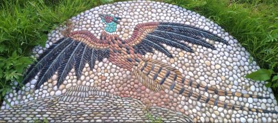
6.4 miles | 10.3 km | 270m Ascent | 7.8 Naismith miles | Kate Rowe This easy walk offers great views and includes a number of the Millennium Mosaics placed around Hawes in 2000. The route starts by crossing the Widdale Beck, then the River Ure before climbing up to Hardraw. From there we go to Simonstone and take a path along the fellside into Sedbusk Village. We start back on the Sedbusk lane, but soon divert left to head down to the River Ure at Haylands Bridge. We then follow the river upstream until we meet the A684 where we walk left along the road for a very brief spell before heading up onto the fells again at Thorns. A path along Spillain Green Sike offers good views of cascading waterfalls before we head back down to a minor road at Appersett Viaduct. From there we follow the road downhill back to the cars. On route we see eight of the twenty two mosaics.
4.7 miles | 7.6 km | 192m Ascent | 5.7 Naismith miles | Peter Lennard The Bentham Footpath Group has a tradition of making the walk between Christmas and New Year an easier and shorter walk than usual, so that we can combine it with a meal at a local venue. Our aim is to make the walk accessible to all our members and to ensure that we can be at our venue by lunchtime. Does that mean the route needs to be dull? Absolutely not – as this walk shows. We start from Langcliffe and then take the path up the western side of the river Ribble as far as Stainforth Force and the historic pack horse bridge. From there we cross the river and take the bridleway into Stainforth village and then over fields to the fascinating Hoffmann Kilns at the old Craven Lime Works. Finally, another short section of field crossings brings us back to Langcliffe.
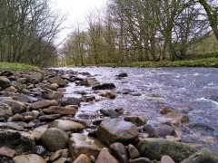
5.2 miles | 10.7 km | 170m Ascent | 6.0 Naismith miles | Alison Kinder & Colin Stroud This easy riverside walk starts from Edisford Bridge in Clitheroe and follows the Ribble downstream, to Mitton Bridge, where we cross and return. The route could easily be combined with a day out in Clitheroe – the castle and museum are well worth visiting. During the summer months, the bridge and the banks of the River Ribble are a magnet for families enjoying picnics; The Bentham Footpath group tackled the walk on a cold and icy winter’s day, so we had the place to ourselves.

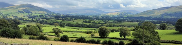
6.5 miles | 10.5 km | 312m Ascent | 8.1 Naismith miles | Sandra Craggs This short and relatively easy walk brings Bentham footpath Group back to the Kent estuary again – and on a good clear day (not the case on the day of the group walk unfortunately) - great views of Farleton Knott, then the Howgills, the Lakeland fells and finally the Kent estuary and the viaduct at Arnside are revealed. Add a curious folly tower, an old railway line that is slated to be converted to a pathway, a toposcope, and a 12th century church with beautiful grounds, to make this a walk well worth the effort. The route is essentially a figure of eight, so there is the opportunity to make it two shorter walks, and as part of this route intersects with other BFG walks, there is scope to use it as a basis for longer combined routes.

7.2 miles | 11.5 km | 411m Ascent | 9.2 Naismith miles | Susan Badley Lord’s Lot is a modest hill in South Lakeland offering tremendous views of the Lakeland peaks to the Northwest and the Howgills to the Northeast. Despite being only a few miles from Windermere this area is refreshingly quiet – the group met no other walkers during our walk despite the near perfect conditions. This circular walk is classed as easy because it’s below our 12km threshold, but you should be aware that there is some climbing up to Lord’s Lot, and that the paths can be muddy in winter. The views make all this worthwhile though, and if you pick a spring day to do this walk, you can also enjoy the spectacular white blossom that the countless damson orchards in the area produce.

6.6 miles | 10.6 km | 312m Ascent | 8.1 Naismith miles | George Sheridan The Howgills, are a firm favourite of Bentham Footpath Group: These distinctive rounded hills with their lovely velvety appearance offer a wide variety of walks with peaks such as The Calf, Calders, and Arant Haw, along with the spectacular waterfall of Cautley Spout. This easy walk does not do any of these big climbs – instead we focus on gaining a great view of the wider area. It starts from New Bridge just outside Sedbergh and then heads East along the Clough River, before turning North at Dovecote Gill. We pass through Dowbiggin and then cross the Hebblethwaite Hall Gill before heading West at Hebblethwaite Hall. We then press on to the A683 via an Alpaca farm at Ghyllas, and after a very short section of road walk take the Pennine Journey path along the Rawthey back to New Bridge.

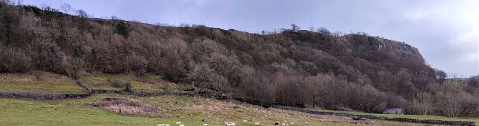
7.4 miles | 11.9 km | 400m Ascent | 9.4 Naismith miles | Sandra Craggs This walk starts from Giggleswick Village and then heads up through Lord’s Wood, past the quarry, to join the top of Giggleswick Scar at Schoolboy’s Tower where we get great views across the Ribble valley. From there we walk along the top of the scar until we meet the path coming up from Buck Haw Brow, when we head North to Feizor Thwaite. A sharp turn back along the Pennine journey path brings us down to Stackhouse, and from there we stroll back to Giggleswick along the side of the Ribble at Settle. Although this walk is classed as easy because it’s (marginally) less than 12 km, be aware that there is a steep climb and some terrain that can be wet and slippery in poor weather.

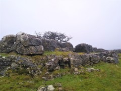
5.9 miles | 9.5 km | 348 m Ascent | 7.6 Naismith miles | Graham Cooper A quick glance at the “Big Map” page on our website shows just how much Bentham Footpath Group favours Austwick as a base for walks, and a look at today’s gallery clearly shows why. For this easy walk, we park near the Traddock Inn and stroll through Austwick and out to the Horton Road where we pick up Townhead Lane to start the climb up to the Erratics. When we meet the Pennine Bridleway we take left to enter the fields that lead up to the Erratics, where we explore for a while, before heading across Nappa Scars and over to the Wash Dubs. From there we walk gently downhill to Wharfe and across to Wood Lane which we follow as far as Austwick Bridge, and the Traddock.
6.4 miles | 10.3 km | 305 m Ascent | 7.9 Naismith miles | Bernie & Sheila Garrett This circular walk starts from Austwick– where there is generally parking available free of charge on the roadside: For this walk we start by the Traddock Hotel. We stroll through Austwick and out to the Horton Road where we pick up the footpath over Flascoe Bridge before taking the bridleway over to Feizor. The Dales Highway then takes us up toward Little Stainforth, but before we get that far we divert up to Smearsett Scar, before looping round to enter the top of Wharfe Wood. We walk through Wharfe Woods, and then through parts of Oxenber wood before heading back downhill to Wood Lane which we follow as far as Austwick Bridge, and the Traddock.

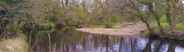
7.0 miles | 11.3 km | 477 m Ascent | 9.4 Naismith miles | Kate Rowe Staveley is a great place to walk, and one that the Bentham Footpath Group has often visited: Not only is the area beautiful, but it’s easily accessible, and relatively quiet when compared with the “honeypot” towns of Kendal and Windermere, between which it sits. This walk falls within the distance and ascent parameters for a BFG “easy” walk, but you should expect some steep climbing as we set of to find three of the tarns on Potter Fell: Potter Tarn itself, then Gurnal Dubs, and finally Ghyll Pool. We return via Hundhowe and Hagg Foot and then track upstream along the banks of the river Kent as it winds through the woodland at Beckmingle Ing.

6.8 miles | 11.0 km | 617 m Ascent | 9.9 Naismith miles | Peter Lennard Pen-y-ghent is the smallest of the “three peaks” at 694m (2277ft). This circular walk goes anticlockwise so that we tackle the steep ascent at the South end of the hill first followed by a gentler downhill return with views over to Horton, Ingleborough, and Hull Pot. BFG walks are rated based on a combination of distance and ascent, and this one is quite short and so is classified as “easy”. Be aware through, that the climb to the peak is steep and rocky, so care is needed.
7.2 miles | 11.6 km | 435 m Ascent | 9.4 Naismith miles | Robert Baines Many people associate Killington with the reservoir and the services on the M6. In fact, the pretty 14th century village that the reservoir is named after is some way to the east of there in the Lune Valley with impressive views over to the Howgills at Sedbergh. This relatively easy walk takes the shape of a figure eight on the OS map – and there are paths to enable either loop of the figure 8 to be walked independently, so two shorter walks can also be found here. Apart from some boggy ground at Tarn Moss, the walking is easy though, so we recommend the walk as published here.
4.1 miles | 6.7 km | 144 m Ascent | 4.8 Naismith miles | Kate Rowe This excellent walk in and around Eldroth takes no more than 2 -3 hours – even with a brief stop at the quarry, and allowing time for several stiles. We start by heading across farmland toward Lawkland with the panoramic views of Giggleswick Scar. Just before Lawkland Hall we double back and cross the railway before heading back to the Eldroth Road where we cross over to the disused quarry. Good views in all directions can be enjoyed from this high spot. A short section of walking on generally empty roads then takes us to Accerhill Hall and Howith Farm before we return to the road at Black Bank Farm We then take a footpath North at Black Bank to come back under the railway to the village hall where the walk ends.
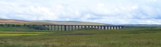
5.7 miles | 9.2 km | 208 m Ascent | 6.8 Naismith miles | Graham Cooper Bentham Footpath Group aims to offer a wide choice of walks, showcasing the wonderful area that we live in. We start at the Ribblehead Viaduct – perhaps the most photographed structure in the Yorkshire Dales, and then set off as if we were heading up Whernside. Just before the Bleamoor signal box though we divert under the railway to track along the contours of Whernside at low level on flat(ish) ground and solid paths. This gives us great views toward Ingleborough. When we meet the path coming back down from the top of Whernside, we go left down Philpin Lane to pick up the return path along the valley bottom to Haws Gill Wheel. This is the only part of the walk where we need to tread carefully as wet limestone can be slippery. We follow Winterscales Beck all the way back to Gunnerfleet Farm and then back under the centre of the viaduct to complete the walk
4.8 miles | 7.7 km | 264 m Ascent | 6.1 Naismith miles | Alan Parker We start from the free car park at Harley Bank and then cross the Wenning to walk up Mill lane as far as Clouds Bank. We then take a path over fields to pick up Eskew Lane at the Punch Bowl, and cross the river again to take the “fairy steps” to West End Farm. From there we take a lane and then a footpath to Goodenburgh Holiday Park, where we cross Ravens Close Brow and take the footpath over to Gill Farm. Here we turn right on Back Lane. This brings us back to Ravens Close Brow at the Solar Farm where we cross the fields to arrive back at Low Bentham at Green Head Farm. We end the walk with a pleasant stroll through the village.
7.3 miles | 11.8 km | 437 m Ascent | 9.5 Naismith miles | Mary & Kate Taylor Wharfedale is an exceptionally beautiful part of the world, and this walk from Conistone shows us the best of it. The first part of the walk involves some hard walking up the Dib – a steep gorge. We then take the Bycliffe road up as far as the Conistone Turf Road where we head onto Conistone Moor and Copplestone Gate. We then head downhill to find the Dales Way again and follow this back to Conistone Pie before returning to Conistone village via Scot Gate Lane. The modest distance means that this is classed as an easy walk, but the clambering up the Dib means that you need to be fit and appropriately clothed / booted.
5.3 miles | 8.6 km | 318 m Ascent | 6.9 Naismith miles | David Longton The Bentham Footpath Group presents walks all over the Yorkshire Dales, Forest of Bowland, South Lakes and associated areas. It’s therefore easy to forget that we have great walks on our own doorstep. This walk then, is a reminder of how lucky we are to live here. The walk also remembers Dorothy Stubbs, a popular group member, and this easy route was chosen to allow as many family and Bentham Footpath Group members to join us as possible. Although the route passes a number of places particularly associated with Dorothy, those who were not lucky enough to know her will still find this a great local walk with excellent views.

7.4 miles | 11.9km | 290 m Ascent | 8.8 Naismith miles | Kate Rowe Staveley is a lovely village sitting on the River Kent upstream of Kendal. Less busy than the Lakes, Staveley has many attractions -as well as excellent walks such as this one, we find a brewery visitor centre, a chocolatier, craft bakery, pubs, cafes and other shops. This easy walk tracks down the banks of the River Kent, through pretty woodland. If your timing is good - and this is best as a spring walk – expect to see the traditional host of golden daffodils. The return journey first heads toward Bell Hill before returning to Staveley through pleasant and gentle farmland with excellent views of the Lakeland fells.
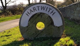
6.6 miles | 10.7 km | 209 m Ascent | 7.7 Naismith miles | Sandra Craggs Dacre Bank is a pretty village on the River Nidd, and our walk starts, and ends, with a sections of the Nidderdale way. In between we visit the nature reserve at Old Spring woods, and the pretty church at Hartwith.
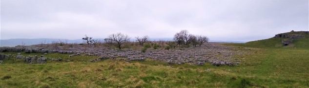
7.1 miles | 11.4 km | 383 m Ascent | 9.0 Naismith miles | Don Cartledge We start in Holme village and pick up the Lancaster Canal heading north and passing Farleton. We then take minor lanes around the back of Farleton Fell, before taking paths over fields to Puddlemire lane and then from Town End Farm up onto the base of Newbiggin Crags at Whin Yeats. The landscape here is dominated by limestone outcrops and spectacular pavements with atmospheric isolated trees that attract many an amateur photographer. We briefly return to a minor lane before cutting through Holmepark Fell, next to the huge Holme Park Quarry, before meeting the A6070 at Holme Park Farm. A short section on the verge of the road returns us to Holme.
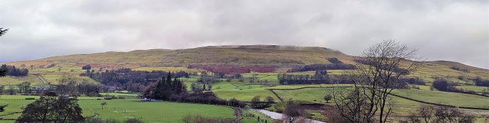
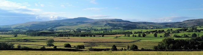
6.4 miles | 10.3 km | 295 m Ascent | 7.9 Naismith miles | Alison Kinder & Colin Stroud Garsdale is one of the less-visited Dales in the Yorkshire Dales National Park, and that’s something of a shame, because it’s particularly attractive. It runs East / West between Baugh Fell to the North, and Rise Hill to the South. This walk starts at a large car park on the A684 with great views of the Howgills, and then heads up the dale on a small and very quiet road following the lower slopes of the imposing Baugh Fell. We return on the other side of the dale following the Clough River past New Bridge before picking up the Sedgwick Geological trail on our way back to the car park.