9.3 miles | 15.0 km | 392 m Ascent | 11.3 Naismith miles | Sandra Craggs
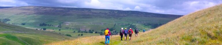
Malham is one of the great attractions of the Yorkshire Dales, and with good reason: Malham Cove is a spectacular sight - as are Goredale Scar, and Janet’s Foss. Slightly further north, and less crowded, is Malham Tarn – one of a very small number of bodies of water in the Dales, and it is from the car park at the Tarn that we set out on this walk.
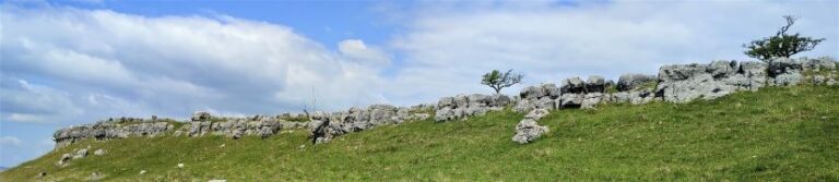
We head up Great Close Hill for views of the Tarn and as far afield as Pendle Hill before picking up the Monk’s Road near Middle House Farm. We then head north toward Arncliffe passing a wonderfully atmospheric ruined farmhouse before pausing to look at some of the best limestone pavement in the Dales. From there we follow the Monks Road along the edge of the steep Yew Cogar Scar until we have a spectacular view over Arncliffe and the Littondale Valley. We take in the views over lunch then return along much of the same route but come back to the Tarn via a different path with a pleasant lakeside end to the walk.
9.6 miles | 15.4 km | 751 m Ascent | 13.3 Naismith miles | Bernie & Sheila Garrett
One of the (many) advantages of living in Bentham is easy access to the Yorkshire Three Peaks. The group has taken various routes up each, and in this excellent walk we tackle Ingleborough again. Why? – because it’s still there as Mallory might say.
Most walkers start at Ingleton, but we take the slightly less common starting point at Clapham and approach the peak via a route that passes Clapdale Wood and Ingleborough Cave. We then take an optional short diversion to look at Trow Gill, before continuing slightly further north to find an easier route uphill across Clapham Bottoms and on to the famous Gaping Gill. After that there’s a steep climb up Little Ingleborough before we finally reach the peak, where we enjoy fine views and note bronze age remains and a demolished hospice. The diversions just tipped us over the 15km limit that we use to mark a walk as challenging but leave those out and it would be moderate – though still steep.
9.9miles | 16.0 km | 333 m Ascent | 11.6 Naismith miles | Sandra Craggs
This walk can be considered to connect with at least two other Bentham Footpath Group walks: It physically shares part of the route of our Copplestone Gate and Conistone Pie walk, and although in a different part of the Yorkshire Dales, it shares much of the industrial heritage of the Gunnerside and Old Gang Smelt Mill walk.
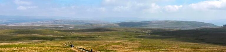
The first half of the walk heads across Downs Pasture to the top of the Dib at Conistone, with great views of the Wharfe Valley and as far South as Pendle Hill. From there we head up the Bycliffe Road to Kelber Gate and then on to Mossdale Scar. The return journey takes us over Grassington Moor and through increasingly bleak, but strangely beautiful lead mining spoils back to the mines at Yarnbury where we spend a while exploring the remnants of this once vast industry.
We rate this walk as Challenging mainly because it’s quite long. There are no particularly steep climbs and there are options to shorten the route if needed.
10.0 miles | 16.1 km | 921 m Ascent | 14.6 Naismith miles | Ed Badley
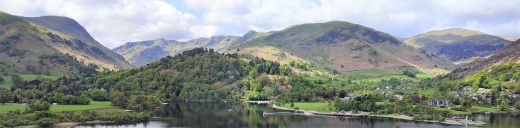
In July 2022, Bentham Footpath Group undertook a challenging linear walk on the Northern side of Ullswater. During that walk we had great views across Ullswater to Place Fell, and this time we return to explore the South side of the lake.
We start from Deepdale Bridge, and initially take a gentle route by contouring around the lake until we get to Scalehow Force. We then head steeply uphill to High Knott, then on to High Dodd, from where we get a good view of the cairn on Place Fell. The strenuous climb to that cairn is rewarded by excellent views across Ullswater to Glenridding, Patterdale and the Kirkstone Pass, before we head downhill - again quite steeply - to Boredale Hause. The final leg of the walk continues downhill to meet the path we used at the start of the walk at the base of Dubhow Crag, before we head back to the cars. This is a strenuous walk, with the more difficult terrain later in the day – so prepare well and make sure you have enough water.

9.8 miles | 15.8 km | 462m Ascent | 12.1 Naismith miles | David Longton
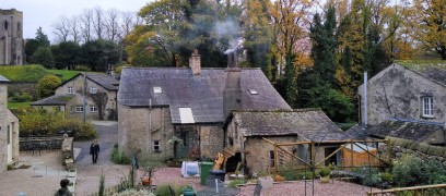
Long Preston is a small village that many people drive through on the way to better known destinations in the Yorkshire Dales. It’s well worth stopping though to explore this village and the excellent walks that can be accessed from it.
The walk we present here is classified as challenging simply because it just exceeds our 15km limit for a moderate walk – but much of the route is on tracks, or minor roads, and there are no steep climbs, so if you feel comfortable with our moderate walks give this one a go too. There are some shortcuts highlighted.
As you can see from the gallery, we picked a wet day to walk it, but in better weather, the views over the Ribble Valley, and the flood plains south of Settle are well worth seeing, as is Scaleber Foss at the halfway point.

9.6 miles | 15.4 km | 530 m Ascent | 12.2 Naismith miles | Susan Badley
The Cartmel Peninsula is a popular starting point for walks, and it features in a number of BFG routes.
This circular walk starts at Low Woods near the River Leven just South of Haverthwaite, then tracks up the valley to Backbarrow. We cross the Fell to Hazelrigg and work South to Seatle. From there we walk through woodland to High Cark, and cross Seatle Plantation to visit Bigland Tarn before working down steepish woodland paths back to our start.
This is quite a long walk, so we list it as challenging, but there are no particularly steep climbs nor difficult terrain, and the views toward Windermere and the Southern Lakeland Fells pay dividends, so if this is slightly longer than your normal limit, it’s still worthy of consideration.
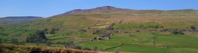
10.4 miles | 16.7 km | 927 m Ascent | 15.0 Naismith miles | Sandra Craggs
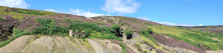
We tend to think of the Yorkshire Dales as a rural idyll, but there is also a great deal of industrial heritage to be found. This walk starts in the lovely village of Gunnerside in Swaledale and then heads up Gunnerside Gill into an area that from the 15th to 19th centuries was the centre of a vast lead mining industry.
We explore remains of the lead mining sites – now mostly reclaimed by nature, before taking the steep scramble to cross Melbecks moor where we find an altogether bleaker and more damaged landscape –the result of lead smelting. This is where we find the Old Gang Smelt Mill, a much larger and toxic operation than the remains we saw at Gunnerside.
From there we walk down to Surrender bridge and then take a return route along the side of Swaledale with fantastic views up the valley to Muker and beyond or down toward Reeth and the North Yorks Moors.
11.0 miles | 17.6 km | 786 m Ascent | 14.9 Naismith miles | Ed Badley
Most of the walks that Bentham Footpath Group offers are circular, but this challenging walk on the Ullswater Way uses public transport to get us back to the starting point – which means that we can cover almost half of the route around the entire lake in one go.
The Ullswater way covers 21 miles in four self-contained sections, 2 of which we cover on this walk: Pooley Bridge to Aira Force via Maiden Castle is about 7 miles –or we press on to Glenridding – a further 4 miles, where the bus awaits.
The notes cover the full 11 mile distance, but we would rate the walk as “moderate” if the shorter route is selected.
9.6 miles | 15.5 km | 454 m Ascent | 11.9 Naismith miles | Sue King
We start in Horton and then walk up to the station where we cross the lines and take the path up to Sulber Nick. Here we turn right along the Pennine Bridleway for a while, but when the bridleway heads East toward the road, we press on North to the entrance to Alum Pot and then head right to take the lane down into Selside.
From Selside we turn left and head over to High Birkwith, crossing the upper reaches of the Ribble, to reconnect with the Pennine Bridleway, which takes us up toward Old Ing. Before we get that far though, we take a sharp right to pick up a path heading South along the contours of Horton Moor.
This eventually comes down to a quiet lane at New Houses which we follow back to Horton.
9.5 miles | 15.3 km | 590 m Ascent | 12.4 Naismith miles | Sandra Craggs
Grisedale is not well known, and often missed by visitors, but there is a simple beauty in this Dale – which is what why we chose this walk.
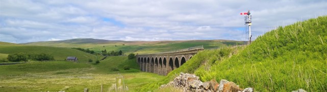
We start at Garsdale Station and then head up Grisedale to East Scale and the Quaker Burial Ground, before walking up Galey hill to Flust where we pick up the Pennine Journey path down to the B6259.
A very short section of road walking takes us to Quarry Farm where we head over fields and through a plantation to Lunds Chapel, before climbing (quite steeply) up the side of Abbotside Common to pick up (Lady Anne’s) High Way. We follow this along the valley side for a while before heading down the Pennine Bridleway to the Cobbles Plantation and Ure Force.
A brief stop at The Moorcock Inn is a recommended option, before crossing the A684 and walking under the impressive Dandry Mire Viaduct to return to the start.
11.4 miles | 18.3 km | 469 m Ascent | 13.7 Naismith miles | David Longton
In the summer months, the light allows for walks that are longer, more challenging and which start from points that are farther from sunny Bentham.
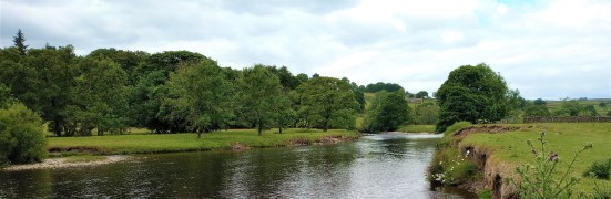
This is the case for this varied walk in Wharfedale that covers rough moorland and a pleasant riverside view, with industrial and medieval heritage and wildlife.
9.8 miles | 15.8 km | 492 m Ascent | 12.3 Naismith miles | Sandra Craggs
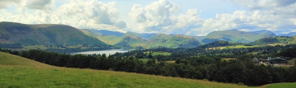
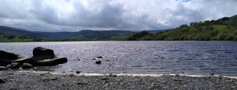
Our walk starts from Bainbridge and initially follows a Roman road known as the Cam High Road up Wensleydale until we overlook Burtersett. We then cross the ridge into Raydale, and head down to Marsett where we cross the river, walk through a nature reserve and over toward the atmospheric old church at Stalling Busk.
From there we track round Semerwater - again in a nature reserve - to visit the lake shore at Turner’s seat. The final part of the walk sees us follow the river Bain back to Bainbridge, with good views over the site of the Roman fort of Virosidum.
Although quite long, and steep in places, this walk offers great views, and an opportunity to explore some of the quieter parts of the Yorkshire Dales.
12.7 miles | 20.5 km | 371 m Ascent | 14.6 Naismith miles | Alison Kinder & Colin Stroud
This walk gives us the opportunity to explore some of the excellent walking country right on our doorstep.
We start in Wray just a few minutes’ drive from Bentham, and walk back to Wennington before heading over to Wrayton. From there we walk back down the Lune Valley to Loyn Bridge and then into Hornby before returning to Wray.
This walk offers a wide variety of landscapes. There are a good number of stiles, but none of the hills are steep.
We grade it as challenging simply because it’s quite long, and if you wanted a shortened version, cutting back to Hornby from Loyn Bridge along the road would be viable.
9.8 miles | 15.8 km | 665 m Ascent | 12.1 Naismith miles | Susan Badley
Starting from a convenient and little-used layby on the A590 at Pool Foot, we head upstream to the village of Bouth. From there we enter Old Hall Woods and head over to Colton before taking a path North to Oxen Park.
We then pick up a woodland route over to Whitestock Hall before a short section on-road brings us to Hulleter. Excellent views across the Rusland Valley and Rusland Moss National Nature Reserve are enjoyed through this section of the walk.
At Hay Bridge we enter the nature reserve with its tranquil tarns, before heading over to Moss Wood. This track brings us back to Bouth, but rather than returning exactly as we started, we now turn right and head toward the woodland at Ashes Intake. We divert back to the causeway south of Bouth before retracing our steps back to the start
11.7 miles | 18.9 km | 811 m Ascent | 15.8 Naismith miles | Jim Shuttleworth
Mallerstang, and the Upper Eden Valley, are among England’s few remaining wild and peaceful places.
David Bellamy described this general area as “England’s last Wilderness”.
This challenging walk has everything: Lady Anne’s way, sculpture, the source of the river Eden, spectacular scars, cairns, disused quarries, incredible views, gentle riverside sections, and even a castle.
Not enough? Pick the right day and you might see a steam train and the RAF in training.
9.5 miles | 15.3 km | 350 m Ascent | 11.2 Naismith miles | David & Sheila Longton
This long but relatively gentle walk starts from Kirkby Lonsdale, and takes quiet lanes through High Casterton to Casterton Village. From here we follow the base of Barbon Low Fell over to Barbon where we cross the A683 and return through Kirkby Lonsdale Golf course before taking a path down the side of the River Lune for a while. We briefly return to Casterton before finding a route back to our starting point via Casterton Golf Course and the caravan park.