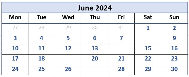
The first June walk is on Saturday 8th, and covers 6 miles around Glasson Dock and the Lancaster Canal spur. The leaders are Alison Kinder and Colin Stroud and the walk starts from the car park at Conder Green – the one listed on Google Maps as: “Conder Green Picnic Site and Car Park”
Walking back from the car park we pass the Stork pub, cross a minor road then along field paths to reach Parkside Farm. Dropping down to Forerigg Wood we reach the Lancaster Canal towpath and follow this to Glasson Marina. Crossing the road, we walk up to the sea wall then follow the route of the old railway track back to the start.. Back to June calendar
On Friday 14th, Mary Taylor takes us on a 7 mile ramble which starts from the car park at Chapel-le-Dale Church. There is a quiet lane behind the church which we follow towards Ellerbeck and turn left at the signpost on to Scales Moor. Walking along Scales Moor we eventually reach the waterfalls walk path and eventually turn left down to Oddies Lane which will lead us back to the start.Back to June calendar
Keasden Church is the start point for our first summers evening stroll on Wednesday 19th, it covers 5 miles and is led by Kate Butcher. Walking first to Turnerford its then uphill to The Heigh and, after crossing fields to West Borranhead, its down to the road leading to Hammon Head and Clapham Woods Farmhouse. Finally, we return to the church via Reeby’s Farm. This is an easy ramble with only some short and gentle uphills. This walk is not considered suitable for dogs.
This walk was created by Kate Rowe, but the leader on the day will be Kate Butcher. Back to June calendar
The last June walk is on Thursday 27th. This is 10 mile “challenging” hike around Malham Tarn and the Monks Road and the leader is Sandra Craggs. Free Parking is at Malham Tarn from where we explore the paths around Great Close Hill and Middle House before encountering a rarely seen limestone pavement. Picking up the Monks Road we continue along Yew Cogar Scar eventually reaching a point just above Arncliffe. Retracing our route, with slight variations, we return to Malham Tarn by the far side of Great Close and the edge of the Tarn. Back to June calendar
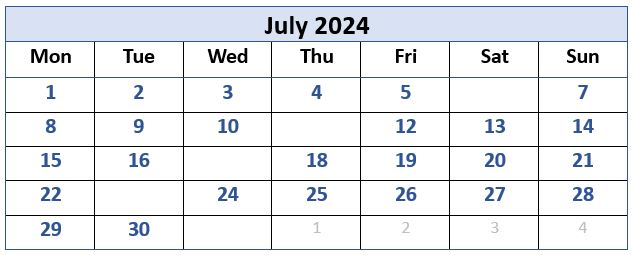
Saturday 6th sees our first 8 mile Kirkby Stephen ramble led by Terri Kwiecinska. Starting from Christian Head free car park (Kirkby Stephen) we pick up the Pennine Journey path along the River Eden to Winton and across fields towards Cote Garth. Its then along a disused railway line above Hartley and across the viaducts to reach Stenkrith Bridge via the poetry stones. We return to the start crossing Frank’s Bridge and by the church. Back to July calendar
The July evening walk, led by Valerie Eccles and Mary Pickstone, is on Thursday 11th. This 3.5 mile stroll starts from Hutton Roof village, from where we climb quickly to Hutton Roof Crags (a site of special scientific interest known for its limestone pavement). At the walks highest point there are extensive views of the Lakeland fells and Bowland moors and as we descend back, the views continue with the Howgills and Ingleborough dominating the skyline. If it’s a nice evening, bring a snack and we can pause at the top to take in the panorama.Back to July calendar
David Longton has an mile walk for us on Wednesday 17th. Please note that the route has been slightly revised:
We park on the free village car park in Rathmell then head up Helsley Lane to Whelp Stone Lodge and on to Welp Stone Crag where weather permitting, we have extensive views over the Ribble Valley one side and the Hodder Valley, including Gisburn Forest the other. We retrace our footsteps for some distance then take the footpath to Higher, Middle and Lower Brayshaw then onto Higher Road to Long Gill on past Boostagill to Layhead Farm then it is down Back Lane to the road through the village to the car park. This will reduce the distance from 9 to 8 miles. Back to July calendar
The 5 mile Kentmere walk is on Tuesday 23rd and led by Don Cartledge. Parking is on Maggs Howe camping site at Kentmere from where we walk past the village church along a good track which leads past the old slate quarries to eventually reach the reservoir. We return alongside the eastern side of the River Kent. Please note that despite the mountainous backdrop, this walk includes no inclines of any significance.Back to July calendar
Finally, on Wednesday 31st, Alison Kinder and Colin Stroud take us on a 6.5 mile ramble round Ravenstonedale. The start is from outside St. Oswolds church, Ravenstonedale, from where we head to Town Head Farm, High Greenside and on to Beckstones Farm. Eventually we reach Newbiggin, where we soon head for Smardale by Browner and join the route of the former Stainmore Railway as far as the Smardalegill viaduct. We walk down to reach the river which we follow back to the start.Back to July calendar
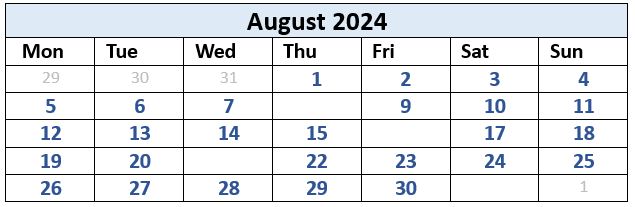
The first walk on Thursday 8th. is led by Bryn and Sandra Craggs and covers 8.5 miles. Parking is at Settle Station where we travel by train to Horton in Ribblesdale. From the station we follow the road and village paths to reach Brackenbottom and continue to Dub Cote and the Pennine Journey path at the base of Pen-y-ghent. Climbing to join Long Lane we head towards Helwith Bridge but turn off onto Moor Head Lane and the Ribble Way down to Stainforth. Then it’s on to Stainforth Scar, Lower Winskill and Langcliffe and back down to Settle. This walk has some significant ascents along the way.
Friday 16th. sees a 7 mile ramble around Cunswick and Scout Scar. George Sheridan is the leader and, for parking, take the Underbarrow road from Kendal centre to the top of the hill on the right and park by the radio station access track. Initially we walk along Cunswick Scar then it’s downhill to Cunswick Hall and along Gamblemire Lane to Tully Thwaite House. We return to the start via Scout Scar and the mushroom indicator shelter. Back to August calendar
Please notea slightly early start: Susan Badley takes us on a 10 mile walk around Spark Bridge and the Leven estuary on Wednesday 21st. The walk starts at Lane Ends (beside the crossroad where the A590 bypasses Haverthwaite, about 3 miles beyond Newby Bridge) and staying north of the road we cross Rusland Pool making our way to Spark Bridge via Tottlebank. Then it’s across the Greenodd-Coniston road to arrive at Penny Bridge and down to the footbridge over the River Leven. The return is mostly level on a former railway line and raised riverbank.Back to August calendar
Finally, on Saturday 31st, there is a 7 mile walk in the Howgills led by Valerie Eccles and Mary Pickstone. Starting from Sedbergh, there is a stiff climb up Winder Fell but the ascent eases to a stroll on the summit with super views of the Lakes, Dales and Morecambe Bay. After an equally steep descent we reach the River Rawthey and return to Sedbergh via the school grounds, playing fields and an unusual summer house known as the pepperpot.Back to August calendar