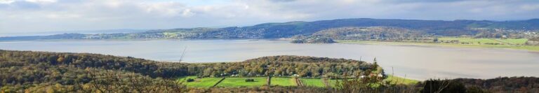
5.3 miles | 8.5 km | 243 m Ascent | 6.5 Naismith miles | Alison Kinder & Colin Stroud We are lucky enough to live in a location that gives us easy access to some of the most beautiful countryside in the UK, and we immediately think of the Lake District, the Yorkshire Dales, and the Forest of Bowland in this context. To that list we must surely add the Arnside and Silverdale Area of Outstanding Natural Beauty (AONB) – a compact but varied area that offers a wide variety of scenery, flora and fauna: One of the smallest AONBs, it covers just 75 km2 between the Kent Estuary, the River Keer and the A6. This easy walk starts from the ever popular seaside village of Arnside, then takes a route along the coastal fringe of the Kent Estuary, looping round to Morecambe Bay at Far Arnside before returning via Heathwaite and onto Arnside Knott with its fantastic viewpoint. We end with a view of the fabulous gnarled trees on the Knott – complete with artworks - before taking a woodland route back to Arnside.
6.3 miles | 10.2 km | 170 m Ascent | 7.2 Naismith miles | Peter Lennard It’s easy to overlook Gargrave as you drive through on the A65, and it would be a mistake to do so: Gargrave is a great place to start a walk, with the added advantage that there are pubs, cafes, and an interesting variety of shops to enjoy. Parking is free and there are good quality public toilets. Still not convinced, then add a walk that includes the Leeds Liverpool canal, parts of the Pennine Way, Country houses, enchanting wells, great views of Sharp Haw, a peaceful memorial garden, a curiously ornate lime kiln, and weather station. Where else other than the Yorkshire Dales would you find so much interest in just six miles?

6.1 miles | 9.8 km | 261 m Ascent | 7.4 Naismith miles | Kate Rowe One of the things that differentiates the Lake District from the Yorkshire Dales is the impervious nature of the rock, which means that lakes and tarns can form in valley bottoms – in the Dales water drains though the limestone. This easy walk focusses on tarns rather than lakes: Tarn Hows was originally three separate tarns, which after landscaping by a former landowner became one larger tarn with water levels controlled by an overspill which feeds a spectacular waterfall. Our route takes us up the side of that waterfall, round the tarns, then to the National Trust visitor centre before heading down through Tarn Hows Wood to Low Yewdale, then on to High Yewdale, over Shepherd’s Bridge, and then through Harry Guards Wood to Yew Tree Tarn. A lovely stroll around the tarn and then a short woodland section completes the walk.

6.8 miles | 11.0 km | 164 m Ascent | 7.6 Naismith miles | David & Sheila Longton Think of Tolkein and Middle Earth, and many people will think of New Zealand – largely because The Lord of the Rings trilogy was filmed there. But where is Middle Earth in reality? We can all agree that Great Britain is the centre of the civilized world – nowhere eats more custard cream biscuits. We also know from our Dunsop Bridge walk that the centre of Great Britain is within the Forest of Bowland. When we find out that Tolkein stayed at Stonyhurst College near Clitheroe whilst writing his masterpiece, it all falls into place: Middle Earth is the route we walk here. We start at Hurst Green, then walk down to the banks of the Ribble, past the confluence with the Calder, upstream to the union with the Hodder, then along the Hodder to pick up a path through the grounds of Stonyhurst College to return to Hurst Green. This excellent easy walk takes less time than watching the films.

7.0 miles | 11.3 km | 140 m Ascent | 7.7 Naismith miles | Graham Cooper Driving through Caton on the A683 is a frequent occurrence for those of us luck enough to live in or around Bentham, and so it’s easy to forget that Caton is a great place to start a walk. It offers easy access to the river Lune, and the Millenium Park path, or as our Claughton or Annas Ghyll Walks showed, the moors above Brookhouse. For this walk, we again start at Bull Beck and then take riverside paths down the Lune to the Crook O’Lune bridge before returning on the other side of the river using the millennium way. The route is a figure of 8 shape so there’s an obvious opportunity to split it into two shorter walks if time is pressing or you want to explore Halton or kill time lazing by the river.

4.5 miles | 7.2 km | 350 m Ascent | 6.5 Naismith miles | Alison Kinder / Colin Stroud A good number of Bentham Footpath Groups walks have centred on Silverdale, and on those we always enjoy views over the Kent estuary toward Hampsfell. In this walk we climb Hampsfell and look the other way, using the viewing platform at the Hospice as our highpoint. We have walked in this area before, using Cartmel as our starting point offering a walk with moderate challenge, so this time we offer slight variation – we start from Grange over Sands and make the walk shorter and easier. The aim here is to give the opportunity to spend time in Grange exploring what this delightful town has to offer.
6.8 miles | 11.0 km | 215 m Ascent | 7.9 Naismith miles | Peter Lennard Of the areas that Bentham Footpath Group walk, the Forest of Bowland is generally the quietest. That’s not to say it doesn’t have its hot spots though, and it’s at one of these – the Beacon Fell Country Park that we start this easy walk. The Country Park has a number of attractions all within a well defined and quite small boundary, so you could easily augment the walk by adding one or more of . . . a sculpture trail, orienteering challenges, waymarked walks around the site, a barbecue site, viewing points, and a visitor centre with café and toilets. The whole site is a Biological Heritage Site, so you may also see interesting and rare flora and fauna. Although we start at the Visitor Centre, we soon leave the site and head down to Brock Bottom, where we pick up the River Brock and head upstream passing Brockmill on the way to Gill Barn Wood. We then enjoy great views of Parlick and Fair Snape Fell before climbing back up to the Beacon Fell site where we wander around the Beacon.

7.1 miles | 11.4 km | 592 m Ascent | 10.0 Naismith miles | Bernie & Sheila Garrett This excellent route showcases just what great walking country we have right on our doorstep. We start from Langcliffe, less than half an hour away from Bentham, and then fill the day with the kind of walking that you might see on one of those “celebrity buys some walking boots” TV shows. We head out of Langcliffe on the Pennine Journey path, hop over to the Pennine Bridleway, and then take a footpath up to Victoria Cave, which we explore for a while before walking along the base of the wonderful Attermire Scar. We follow that round, passing under the entrance to Horseshoe Cave, before heading over to Stockdale Lane with great views over to Pendle Hill, and Rye Loaf Hill. We then cut back along a footpath between High Hill and Sugar Loaf Hill to arrive at the base of the Warrendale Knotts. From here we retrace our outbound journey – although in this direction the views are surprisingly different -and then as a bonus treat, pop up to the smaller Jubilee Cave. The final part of the walk follows our outward route back to Langcliffe.

6.2 miles | 10.0 km | 321 m Ascent | 7.8 Naismith miles | George Sheridan The Howgills are a great place to walk – and a firm favourite of the Bentham Footpath Group. The hills here are formed from Ordovician and Silurian rocks, rather than the Carboniferous limestone elsewhere in the Yorkshire Dales, giving them a characteristic rounded appearance and a lovely velvety texture. The Howgills are found in the triangle between Sedbergh, Kirkby Stephen and Tebay, and its to the latter that we go for this walk. We start in Tebay village, and then head up onto the hills following the edge of Tebay Fell to the south with great views over the valley to Borrowdale until we get to the peak of Blease Fell where the vista down the Lune Valley as far as Morecambe Bay makes the climb seem well worthwhile. We then head round the fell, and back over a flattish top via Hare Shaw cairn, Weather Hill, and Waskew Head to cross Tebaygill Beck at a picturesque stone bridge, before returning to Tebay.

4.5 miles | 7.3 km | 117 m Ascent | 5.1 Naismith miles | Kate Rowe During the summer months, Bentham Footpath Group generally offers a walk in the evening – the aim is to take a short and easy stroll out of the heat of the afternoon sun, ideally with a brilliant sunset as a backdrop. Things don’t always work out as we plan though – so although this is a great walk, the weather was not ideal, and our focus shifted to rainbows, brooding skies, unseasonably early fungi and unexpected streams – all equally beautiful in their own way. Shorter walks mean that it makes sense to start nearer to home, so we set off from Keasden Church just 5 miles from Bentham, and then took a meandering route made up of three intersecting loops – hence the name “Keasden Wander”. Each of those loops offers an opportunity to shorten the route, or indeed to connect with other paths to extend it, so as well as being a good walk in its own right, this route can be the basis for a longer full day of walking.

6.7 miles | 10.8 km | 346 m Ascent | 8.5 Naismith miles | Terri Kwiecinska In April this year, Bentham Footpath Group enjoyed a great walk at Storth and Arnside - that walk starts with a great view over the Kent estuary toward Whitbarrow Scar. This time we are on the other side of the estuary climbing Whitbarrow Scar and exploring the interesting geology of the area. Whitbarrow Scar is designated as a Site of Special Scientific Interest, a National Nature Reserve, and a Special Area of Conservation, but still manages to offer easily accessible walks without being too crowded. The route we take is loosely based on the Whitbarrow Geotrail – you can purchase a booklet describing that at the starting point. If geology is not your thing don’t worry – there are great views, fossils, birds of prey, abundant wildflowers, monuments, abandoned mines, forest trails, and newts to be seen too.

7.2 miles | 11.6 km | 261 m Ascent | 8.5 Naismith miles | Kate Rowe In January 2023, Bentham Footpath Group enjoyed a fine walk from Appersett exploring parts of the Hawes 2000 Mosaic project. We saw about half of the 22 mosaics on that day, and we finish the task with this equally fine walk. Starting from Hawes town centre, we head up to Burtersett, take Shaws Lane to Gayle, then head up Sleddale to see Aysgill Force. We return along a Green Lane back toward Gayle, before taking a final detour along Bands Lane and then the Cam Road. A (very) brief section on the B6255 brings us to a path back over fields into Hawes. This is a great walk with fine views, add in the mosaics, a roman road, an impressive waterfall, and all the delights of Hawes, and we have a recipe for a perfect day.

5.7miles | 9.2 km | 181 m Ascent | 6.6 Naismith miles | Mary Taylor This easy route - ideal for a summer evening stroll - starts from Bentham and heads into open countryside to the South of the town, passing Lower Flannagill before entering Lancashire at Moorlands. We then go via Fleet House to Whitepits Lane, and then follow County Beck, which marks the county boundary, up to Oakhead. We head west for a while before passing Oak Bank on the way to Mewith Lane and the County Beck again. We follow this – still in Lancashire - until we get to Kirkbeck where we cross back into Yorkshire, and head across fields back to Bentham. This walk offers a variety of excellent views, wild flowers, glimpses of old mining activity, and lots of livestock. There are no steep climbs, but sections have the potential to be boggy after wet weather.

6.9 miles | 11.2 km | 408 m Ascent | 9.0 Naismith miles | Sandra Craggs Bentham Footpath Group has started walks from Keld before – it’s at the top end of Swaledale. On the last occasion - in November 2022 - we headed up to Whitsundale, seeing the rivers that merge to form the Swale in full flow. This slightly gentler summer walk takes us downstream to Muker via the Pennine Way, where having explored the village a little we walk through the ever popular wildflower meadows before returning on the far side of the river via Swinner Gill then Crackpot Hall and finally East Stonesdale waterfalls. You will notice from the gallery that the Swale was barely a trickle after a prolonged dry spell – such a contrast to our last visit.

6.5 miles | 10.5 km | 155 m Ascent | 7.3 Naismith miles | Don Cartledge Bentham Footpath Group considers the Yorkshire Dales, the Forest of Bowland and the South Lakes to be our home territory, and we often venture further afield during the summer months when the days are longer. However, it’s nice to remind ourselves just how beautiful the countryside on our own doorstep is, and to make the most of the flatter land in the flood plain of the Ribble Valley. This easy walk loops out from Wigglesworth to the curiously named Hard Head Farm, then over to Cappleside before picking up the Ribble Way to return through the Long Preston Flood Plain Project, Cow Bridge and then via gentle fields back to Wigglesworth, where there is a very inviting pub.

6.5 miles | 10.5 km | 351 m Ascent | 8.2 Naismith miles | Kate Rowe The clue is in the name as they say . . . this walk features the woodland in Roeburndale, and the spectacular bluebells and other wildflowers that make the most of the spring light that reaches the woodland floor just before the trees get into full leaf. Timing is everything, as this phase of spring lasts for just a couple of weeks; we scheduled our walk for early May. Is this a worthwhile walk at any other time? It absolutely is. Roeburndale, like the rest of the Forest of Bowland is quieter than the Dales or Lakes, yet this particular part of it is very accessible. The village of Wray has an interesting history, and an excellent tearoom. On the walk we pass an abandoned rope bridge, a hidden orchard, see slow worms, and there are great views over the three peaks. So, this is a great walk at any time, and or is perfect in early May.

6.9miles | 11.1 km | 329 m Ascent | 8.5 Naismith miles | Bernie & Sheila Garrett What are the ingredients for a perfect walk? For some it’s something easily accessible with good parking and not too far from home, perhaps with riverside walks, and a waterfall or two. Or you may prefer ancient packhorse bridges, and traditional village greens, and perhaps a war memorial and village church. Or water mills and abandoned industrial remains excite you. This walk has all of these and is so densely packed with interest that all this is delivered within our 12 km limit for an easy walk. What more could you want? No wonder we had such a good turn out for this walk.

6.1 miles | 9.9 km | 313 m Ascent | 7.7 Naismith miles | Mary & Kate Taylor Bentham is a great place to live – particularly for those who like walking: We have access to the Yorkshire Dales, the Lake District, and as we see in this walk, the Forest of Bowland. Of that trio, the Forest of Bowland is the least visited, so it’s possible to find a quiet walk with unspoiled countryside, without seeing anyone else all day. This easy, but interest-filled walk starts from a free car park at Little Cragg outside Brookhouse. The high farmland here offers great views over Morecambe Bay to the Lakeland Fells, before we drop down and cross the Udale Bridge, then climbing up to Crossgill with Caton Moor on our left and Littledale Hall on our right. We head up one side of the valley at high level and then descend to the river (Closegill Beck) to return at low level, before exploring the woodlands next to the Hall and then heading back via Littledale and Sweet Beck to Little Cragg.

7.4 miles | 12.0 km | 183 m Ascent | 8.3 Naismith miles |Sue King Arnside is a firm favourite of the Bentham Footpath Group, and this is the second walk in this area in the 2023 spring program. So why do we like Arnside so much? Well, where else can you find an easy walk that combines a sandy estuary with a backdrop of the Lakeland fells, a disused railway track bed converted into a safe and accessible path, industrial archaeology, beautiful riverside meadows, a country house and deer park, an ancient corpse road, atmospheric paths through rock fissures, a pele tower, and a seaside town with a unique railway viaduct. The entire area is designated as an Area of Outstanding Natural Beauty (AONB) so expect to see interesting flora and fauna too.

6.3 miles | 10.1 km | 248 m Ascent | 7.5 Naismith miles | Peter Lennard The Dent Foot walk that we completed on 17/03/23, connected with two of the three rivers in and around Sedbergh – the Rawthey and the Dee. This walk completes the set by adding the Lune. We start by heading out onto the fells at the base of Winder, with great views over to the Lune Valley and the disused railway viaduct. We then cross farmland to pick up the Dales Way and have a close look at the spectacular viaduct. From there we follow the Lune downstream before cutting back to Ingmire Hall. Next, we head down to the beautiful Friends Meeting House at Brigflatts, and finish by following the Rawthey upstream back to Sedbergh. The walk is classified as easy - althtough there is a bit of a climb at the start.

7.1 miles | 11.5 km | 374 m Ascent | 9.0 Naismith miles | Sandra Craggs Living in and around the Dales means that we often drive through Gargrave, and as we exit the town on the Skipton side, we see an attractive fell ahead of us with a wooded side and a ridge that looks inviting as a walking area. That’s our destination for this walk: The woods are Crag Wood, and the peak behind them is Sharp Haw and Flasby Fell. Rather than approaching them from Gargrave though, we head over to the B6265 Grassington Road so that we approach Sharp Haw from the Southeast on the Dales High Way. This route keeps more of the spectacular view over the Ribble and Aire Valleys hidden until a big reveal at the peak of Sharp Haw. We then continue round Flasby Fell to Flasby Village and return via forestry tracks through High Wood and Crag Wood, enjoying excellent views over Gargrave toward Clitheroe.

6.5 miles | 10.5 km | 283 m Ascent | 7.9 Naismith miles | John Smithson The triangle formed by the pinch point of the M6 and the A65 is often overlooked as a walking area – it’s not the Yorkshire Dales, and it’s not the Lakes – it’s not even the Forest of Bowland. But it is easy to reach, it offers great walks and not surprisingly then, is popular with The Benham Footpath Group. This relatively easy walk focusses on Dalton Crags – the area of limestone pavement to the South of Hutton Roof. We start at Plain Quarry car park and then meander South through the rolling hills around Dalton Old Hall before heading back up to Burton-in-Kendal where we pick up the path along Slape Lane and into Pickles Wood, before taking a track through Storth Wood. This takes us part way up Dalton Crags, where we have a good look at the limestone pavement before heading back down to the car park.

6.4 miles | 10.3 km | 236 m Ascent | 7.5 Naismith miles | Don Cartledge Arnside is a favourite with Bentham Footpath Group – this small and very accessible area provides a huge variety of interesting features such as The Knott, a tidal bore, estuary views, a Pele tower, a Marylin, a wonderful railway bridge, Victorian architecture, rare butterflies, atmospheric distorted trees, and a seaside promenade. This walk forms a figure of eight shape, so there is a good opportunity to approach it as two smaller walks, or because there are so many paths in the area, there are many ways that it could be combined with other BFG walks in our library to make a more challenging route.

5.9 miles | 9.5 km | 181 m Ascent | 6.8 Naismith miles | Graham Cooper Just a short distance from home, this walk is easy and short enough to do in a morning or afternoon when the opportunity arises, and the weather promises fine views. It features great views of the three peaks, a heronry, wild deer, a bailey bridge, listed buildings, nature reserves, academic research sites, and given that it runs along the Settle to Carlisle railway, the off-chance that you will see a steam train or be buzzed by the RAF. What more could you want in less than 6 miles?