Pennine Way

Malham Tarn and the Monks Road

9.3 miles | 15.0 km | 392 m Ascent | 11.3 Naismith miles | Sandra Craggs
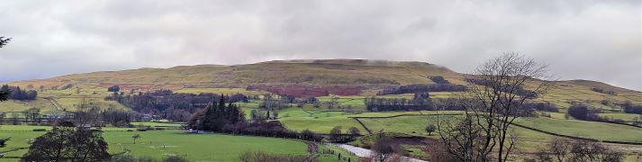
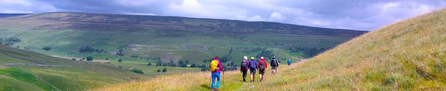
Malham is one of the great attractions of the Yorkshire Dales, and with good reason: Malham Cove is a spectacular sight – as are Goredale Scar, and Janet’s Foss. Slightly further north, and less crowded, is Malham Tarn – one of a very small number of bodies of water in the Dales, and it is from the car park at the Tarn that we set out on this walk.
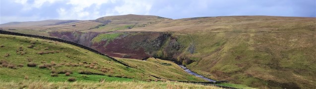
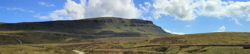
We head up Great Close Hill for views of the Tarn and as far afield as Pendle Hill before picking up the Monk’s Road near Middle House Farm. We then head north toward Arncliffe passing a wonderfully atmospheric ruined farmhouse before pausing to look at some of the best limestone pavement in the Dales. From there we follow the Monks Road along the edge of the steep Yew Cogar Scar until we have a spectacular view over Arncliffe and the Littondale Valley. We take in the views over lunch then return along much of the same route but come back to the Tarn via a different path with a pleasant lakeside end to the walk.

Malham Tarn and the Monks Road Read More »

Far Moor Bridge and Ribblesdale

7.8 miles | 12.6km | 297 m Ascent | 9.3 Naismith miles | Sandra Craggs
Horton in Ribblesdale is a great place to start a walk, and the “three peaks” are the big draw with Pen-y-Ghent an obvious choice, as is the Sulber Nick route over to Ingleborough.
Both are good walks, but there is much else to see in this area, as we show with a route including a tarn, the stunning Far Moor Bridge, disappearing rivers, atmospheric lime kilns, a National Nature Reserve, extensive limestone pavement, and vast quarries, all of which is accessible via the Settle to Carlisle railway. What more could you want? A blue lagoon? – well there was one until recently, and we can offer pictorial evidence.

Far Moor Bridge and Ribblesdale Read More »

Gargrave and Eshton

6.3 miles | 10.2 km | 170 m Ascent | 7.2 Naismith miles | Peter Lennard
It’s easy to overlook Gargrave as you drive through on the A65, and it would be a mistake to do so: Gargrave is a great place to start a walk, with the added advantage that there are pubs, cafes, and an interesting variety of shops to enjoy. Parking is free and there are good quality public toilets.
Still not convinced, then add a walk that includes the Leeds Liverpool canal, parts of the Pennine Way, Country houses, enchanting wells, great views of Sharp Haw, a peaceful memorial garden, a curiously ornate lime kiln, and weather station. Where else other than the Yorkshire Dales would you find so much interest in just six miles?

Gargrave and Eshton Read More »

Hawes Mosaics (Part 2)

7.2 miles | 11.6 km | 261 m Ascent | 8.5 Naismith miles | Kate Rowe
In January 2023, Bentham Footpath Group enjoyed a fine walk from Appersett exploring parts of the Hawes 2000 Mosaic project. We saw about half of the 22 mosaics on that day, and we finish the task with this equally fine walk.
Starting from Hawes town centre, we head up to Burtersett, take Shaws Lane to Gayle, then head up Sleddale to see Aysgill Force. We return along a Green Lane back toward Gayle, before taking a final detour along Bands Lane and then the Cam Road.
A (very) brief section on the B6255 brings us to a path back over fields into Hawes. This is a great walk with fine views, add in the mosaics, a roman road, an impressive waterfall, and all the delights of Hawes, and we have a recipe for a perfect day.

Hawes Mosaics (Part 2) Read More »

Keld to Muker meadows

6.9 miles | 11.2 km | 408 m Ascent | 9.0 Naismith miles | Sandra Craggs
Bentham Footpath Group has started walks from Keld before – it’s at the top end of Swaledale. On the last occasion – in November 2022 – we headed up to Whitsundale, seeing the rivers that merge to form the Swale in full flow.
This slightly gentler summer walk takes us downstream to Muker via the Pennine Way, where having explored the village a little we walk through the ever popular wildflower meadows before returning on the far side of the river via Swinner Gill then Crackpot Hall and finally East Stonesdale waterfalls. You will notice from the gallery that the Swale was barely a trickle after a prolonged dry spell – such a contrast to our last visit.

Keld to Muker meadows Read More »

Appersett Mosaics

6.4 miles | 10.3 km | 270m Ascent | 7.8 Naismith miles | Kate Rowe
This easy walk offers great views and includes a number of the Millennium Mosaics placed around Hawes in 2000.
The route starts by crossing the Widdale Beck, then the River Ure before climbing up to Hardraw. From there we go to Simonstone and take a path along the fellside into Sedbusk Village. We start back on the Sedbusk lane, but soon divert left to head down to the River Ure at Haylands Bridge.
We then follow the river upstream until we meet the A684 where we walk left along the road for a very brief spell before heading up onto the fells again at Thorns. A path along Spillain Green Sike offers good views of cascading waterfalls before we head back down to a minor road at Appersett Viaduct. From there we follow the road downhill back to the cars. On route we see eight of the twenty two mosaics.

Appersett Mosaics Read More »

Whitsundale from Keld

8.1 miles | 13.1 km | 578 m Ascent | 11.0 Naismith miles | Jim Shuttleworth
Swaledale is a great place to walk, and Keld is always a good place to start; There is convenient parking at Park Lodge farmyard with a handy tearoom serving locally made ice creams during the summer season.
Swaledale is famous for its fast flowing river, and this is so because a number of side dales each with their own river merge with the Swale within a short distance of each other.
As well as Swaledale itself, this moderate walk visits three of the side dales that connect with Swaledale – East Stonesdale, West Stonesdale and Whitsundale.
Most of the route is on clearly marked paths – some of them long distance routes, and there is some road walking on quiet roads, so navigation should be simple. Be aware through that Swaledale can be very wet, and as you can see from the gallery, winter walks in this area can damp and windy. Don’t let that put you off though – this is a walk to savour at any time of the year.

Whitsundale from Keld Read More »

Pen-y-ghent

6.8 miles | 11.0 km | 617 m Ascent | 9.9 Naismith miles | Peter Lennard
Pen-y-ghent is the smallest of the “three peaks” at 694m (2277ft).
This circular walk goes anticlockwise so that we tackle the steep ascent at the South end of the hill first followed by a gentler downhill return with views over to Horton, Ingleborough, and Hull Pot.
BFG walks are rated based on a combination of distance and ascent, and this one is quite short and so is classified as “easy”. Be aware through, that the climb to the peak is steep and rocky, so care is needed.

Pen-y-ghent Read More »

Airton to Malham Circular

9.1 miles | 14.7 km | 541 m Ascent | 11.8 Naismith miles | Graham Cooper
Malham is one of the “honeypot” destinations in the Yorkshire Dales, so parking can be problematic and crowds can be an issue. This walk cleverly manages to pass through Malham and some of its many attractions whilst starting and finishing in the much more secluded village of Airton.
The walk starts with a long and steady trek up onto Calton Moor climbing more than 500m before merging with The Dales Highway which we follow down to the bottom of Gordale Scar. From there we walk down past Janet’s Foss into Malham where after a short break we head along the Pennine way and the River Aire back down to Airton via Hanlith.

Airton to Malham Circular Read More »

Gargrave and Leeds to Liverpool Canal

7.4 miles | 12.0 km | 375 m Ascent | 9.3 Naismith miles | Kate Rowe
We start from Gargrave village where there is ample free parking and public toilets, as well as shops and refreshment opportunities, before crossing the River Aire to pick up the Pennine way.
This well trodden path takes us to the unusual double bridge at East Marton, where we turn round and return via the towing path of Britain’s longest canal.

Gargrave and Leeds to Liverpool Canal Read More »