February 2023

Dalton Crags

6.5 miles | 10.5 km | 283 m Ascent | 7.9 Naismith miles | John Smithson
The triangle formed by the pinch point of the M6 and the A65 is often overlooked as a walking area – it’s not the Yorkshire Dales, and it’s not the Lakes – it’s not even the Forest of Bowland. But it is easy to reach, it offers great walks and not surprisingly then, is popular with The Benham Footpath Group.
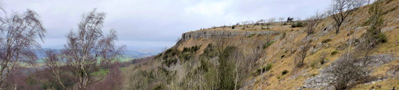
This relatively easy walk focusses on Dalton Crags – the area of limestone pavement to the South of Hutton Roof. We start at Plain Quarry car park and then meander South through the rolling hills around Dalton Old Hall before heading back up to Burton-in-Kendal where we pick up the path along Slape Lane and into Pickles Wood, before taking a track through Storth Wood. This takes us part way up Dalton Crags, where we have a good look at the limestone pavement before heading back down to the car park.

Dalton Crags Read More »

Arnside

6.4 miles | 10.3 km | 236 m Ascent | 7.5 Naismith miles | Don Cartledge
Arnside is a favourite with Bentham Footpath Group – this small and very accessible area provides a huge variety of interesting features such as The Knott, a tidal bore, estuary views, a Pele tower, a Marylin, a wonderful railway bridge, Victorian architecture, rare butterflies, atmospheric distorted trees, and a seaside promenade.
This walk forms a figure of eight shape, so there is a good opportunity to approach it as two smaller walks, or because there are so many paths in the area, there are many ways that it could be combined with other BFG walks in our library to make a more challenging route.

Arnside Read More »

Selside and Ribblehead

5.9 miles | 9.5 km | 181 m Ascent | 6.8 Naismith miles | Graham Cooper
Just a short distance from home, this walk is easy and short enough to do in a morning or afternoon when the opportunity arises, and the weather promises fine views.
It features great views of the three peaks, a heronry, wild deer, a bailey bridge, listed buildings, nature reserves, academic research sites, and given that it runs along the Settle to Carlisle railway, the off-chance that you will see a steam train or be buzzed by the RAF.
What more could you want in less than 6 miles?

Selside and Ribblehead Read More »

Scout Scar and Underbarrow

5.7 miles | 9.1 km |255 m Ascent | 6.9 Naismith miles | Alison Kinder & Colin Stroud
The area of the South Lakes between the Kent and Levens Estuaries provides a rich source of walks and is particularly favoured by The Bentham Footpath Group. This walk shows why: It’s relatively short and generally easy, but still manages to deliver spectacular views, well preserved industrial archaeology, a roman road, an ancient pele tower, sites of special scientific interest and ancient woodlands.

Scout Scar and Underbarrow Read More »