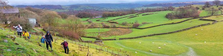
March 2024

Winster Valley

8.3 miles | 13.3 km | 391 m Ascent | 10.2 Naismith miles | Kate Rowe
Spring is such an optimistic time of the year, and getting out and about on a walk with friends is a great way to experience it. So the Bentham Footpath Group have developed an informal habit of taking a walk each year that celebrates the season by picking a route that features the best of the new daffodils or bluebells.
So, here is a “daffodil walk”, and as all Wordsworth fans will appreciate, it really has to be in the Lake District to be authentic – which means of course that as well as the spring flowers we get great views of the fells, tranquil tarns and on this walk, links to Arthur Ransome.
Although our focus was the daffodils, this is a great walk at any time of the year. We rate it as “moderate” based on distance and elevation change but you should be aware that it can feel challenging under wetter conditions.

Winster Valley Read More »

Flookburgh, Cark and the coast

8.3 miles | 13.4 km | 138 m Ascent | 9.0 Naismith miles | David & Sheila Longton
A number of Bentham Footpath Group walks feature views of Morecambe Bay – usually with the Kent or Levens estuaries as the backdrop to higher level walks such as those at Cartmel or Silverdale. This time we do the full seaside experience: Starting at Flookburgh, we walk along the coast getting sand on our boots for a while, before heading inland to Cark, on to Low Bank Side, then across the valley to Templand before returning on a route running through trees below Boarbank Hall. On the way we pass old airbases from both world wars, atmospheric salt marshes, bridleways across the bay, signs of the old shrimping industries, grand Italianate houses, and the odd lime kiln.

Flookburgh, Cark and the coast Read More »

The High Way Upper Wensleydale

7.1 miles | 11.5 km | 371 m Ascent | 9.0 Naismith miles | George Sheridan
Walking is a somewhat weather-dependant hobby, and this route demonstrates that clearly: When we completed our Grisedale and Garsdale walk in this area in June 2022, we enjoyed bright sunshine, walked over dry fields, and asked ourselves why bridges had been provided to cross mere trickles of streams. Fast forward to the wettest start to year that anyone can remember, and we see why the bridges are there – those same streams are now small rivers in full flow.
So, does the rain spoil the experience? Not at all, it just gives us a different perspective: Wonderful waterfalls roar into life, mosses and lichens proliferate, and we get extra exercise jumping over streams and fighting to stay upright on muddy descents. Whatever the weather, this walk offers a great deal – we rate it as easy based on the distance and ascent but be aware that there are steep sections and in the event of poor conditions, extra care is needed.

The High Way Upper Wensleydale Read More »

Far Moor Bridge and Ribblesdale

7.8 miles | 12.6km | 297 m Ascent | 9.3 Naismith miles | Sandra Craggs
Horton in Ribblesdale is a great place to start a walk, and the “three peaks” are the big draw with Pen-y-Ghent an obvious choice, as is the Sulber Nick route over to Ingleborough.
Both are good walks, but there is much else to see in this area, as we show with a route including a tarn, the stunning Far Moor Bridge, disappearing rivers, atmospheric lime kilns, a National Nature Reserve, extensive limestone pavement, and vast quarries, all of which is accessible via the Settle to Carlisle railway. What more could you want? A blue lagoon? – well there was one until recently, and we can offer pictorial evidence.

Far Moor Bridge and Ribblesdale Read More »

Dentdale circular

5.7 miles | 9.2 km | 248 m Ascent | 6.9 Naismith miles | Peter Lennard
We start by Church Bridge, and then loop up onto the fell at South Lord’s Land before walking behind the village, with great views across the valley, and then over to Gawthrop, before crossing meadows to get to Barth Bridge. From there we pick up the Dales Highway long distance path and follow it up to Lunds where we walk on an ancient green lane for a while. We soon head right and onto North Lord’s Land looking across the valley with views of where we walked in the morning. Finally, we return to Barth Bridge via High Barth and then take a very quiet road walk on the North of the Dee before one more section through fields back to Church Bridge.

Dentdale circular Read More »