September 2023

Ribblehead & Chapel-le-Dale

7.8 miles | 12.5 km | 206 m Ascent | 8.8 Naismith miles | Valerie Eccles & Mary Pickstone
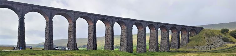
The Ribblehead Viaduct is probably the most photographed railway bridge in the UK, and an icon of the Yorkshire Dales. It’s more than just a bridge though; surrounded by stunning countryside, and with traces of industrial archaeology dating back to its construction, there’s lots to see. So where better to start a walk?
From Ribblehead, we head under the viaduct and over to Gunnerfleet before following Winterscales Beck down to the intriguing Haws Gill Wheel where the river disappears and then reappears. After a very short section of road walk, we pause at the lovely St Leonards Church, before heading up to Ellerbeck, passing a sculpture as we go, and from there take the Dales Highway back to the railway. After a brief look at the Signal Box at Blea Moor, we return via the Viaduct with views over to Ingleborough and Simon Fell.
The Dales’ favourite railway, that bridge, a disappearing river, a beautiful church, art, and great views.

Ribblehead & Chapel-le-Dale Read More »

The Tolkein Trail

6.8 miles | 11.0 km | 164 m Ascent | 7.6 Naismith miles | David & Sheila Longton
Think of Tolkein and Middle Earth, and many people will think of New Zealand – largely because The Lord of the Rings trilogy was filmed there. But where is Middle Earth in reality?
We can all agree that Great Britain is the centre of the civilized world – nowhere eats more custard cream biscuits. We also know from our Dunsop Bridge walk that the centre of Great Britain is within the Forest of Bowland.
When we find out that Tolkein stayed at Stonyhurst College near Clitheroe whilst writing his masterpiece, it all falls into place: Middle Earth is the route we walk here. We start at Hurst Green, then walk down to the banks of the Ribble, past the confluence with the Calder, upstream to the union with the Hodder, then along the Hodder to pick up a path through the grounds of Stonyhurst College to return to Hurst Green. This excellent easy walk takes less time than watching the films.

The Tolkein Trail Read More »

Lune Bridges

7.0 miles | 11.3 km | 140 m Ascent | 7.7 Naismith miles | Graham Cooper
Driving through Caton on the A683 is a frequent occurrence for those of us luck enough to live in or around Bentham, and so it’s easy to forget that Caton is a great place to start a walk.
It offers easy access to the river Lune, and the Millenium Park path, or as our Claughton or Annas Ghyll Walks showed, the moors above Brookhouse.
For this walk, we again start at Bull Beck and then take riverside paths down the Lune to the Crook O’Lune bridge before returning on the other side of the river using the millennium way. The route is a figure of 8 shape so there’s an obvious opportunity to split it into two shorter walks if time is pressing or you want to explore Halton or kill time lazing by the river.

Lune Bridges Read More »

Hampsfell from Grange

4.5 miles | 7.2 km | 350 m Ascent | 6.5 Naismith miles | Alison Kinder / Colin Stroud
A good number of Bentham Footpath Groups walks have centred on Silverdale, and on those we always enjoy views over the Kent estuary toward Hampsfell. In this walk we climb Hampsfell and look the other way, using the viewing platform at the Hospice as our highpoint.
We have walked in this area before, using Cartmel as our starting point offering a walk with moderate challenge, so this time we offer slight variation – we start from Grange over Sands and make the walk shorter and easier. The aim here is to give the opportunity to spend time in Grange exploring what this delightful town has to offer.

Hampsfell from Grange Read More »