Easy

Holmepark Fell

7.1 miles | 11.4 km | 383 m Ascent | 9.0 Naismith miles | Don Cartledge
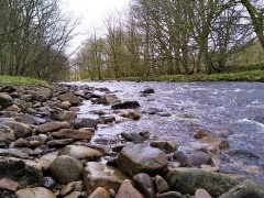
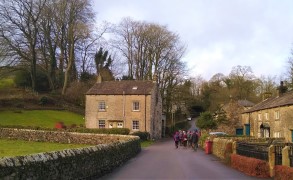
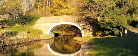
We start in Holme village and pick up the Lancaster Canal heading north and passing Farleton.
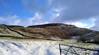
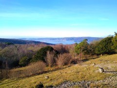
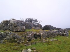
We then take minor lanes around the back of Farleton Fell, before taking paths over fields to Puddlemire lane and then from Town End Farm up onto the base of Newbiggin Crags at Whin Yeats. The landscape here is dominated by limestone outcrops and spectacular pavements with atmospheric isolated trees that attract many an amateur photographer.
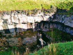
We briefly return to a minor lane before cutting through Holmepark Fell, next to the huge Holme Park Quarry, before meeting the A6070 at Holme Park Farm. A short section on the verge of the road returns us to Holme.

Holmepark Fell Read More »

Lower Garsdale

6.4 miles | 10.3 km | 295 m Ascent | 7.9 Naismith miles | Alison Kinder & Colin Stroud
Garsdale is one of the less-visited Dales in the Yorkshire Dales National Park, and that’s something of a shame, because it’s particularly attractive. It runs East / West between Baugh Fell to the North, and Rise Hill to the South.
This walk starts at a large car park on the A684 with great views of the Howgills, and then heads up the dale on a small and very quiet road following the lower slopes of the imposing Baugh Fell.
We return on the other side of the dale following the Clough River past New Bridge before picking up the Sedgwick Geological trail on our way back to the car park.

Lower Garsdale Read More »

Lancaster: City and Country

6.6 miles | 10.6 km | 319 m Ascent | 8.2 Naismith miles | Susan Badley
Walking from a city centre is unusual for The Bentham Footpath Group. This interesting walk starts in Lancaster city centre and takes the Lancaster Canal South to the Fairfield Nature Reserve, where we loop round the “Fauna”, “Flora” and community orchard areas to arrive back at the canal.
We then head through Aldcliffe to the Lune estuary and the Lancashire Coastal Way, before returning via Freemans Woods to the city centre.
Good views of the Priory and Castle end this refreshing walk.

Lancaster: City and Country Read More »

Challan Hall and Arnside Tower

7.3 miles | 11.7 km | 439 m Ascent | 9.4 Naismith miles | Alison Kinder & Colin Stroud
Silverdale and Arnside are great walking locations – Bentham Footpath Group often base walks in this area.
This walk includes the Knott and it’s great views before heading to an ancient “pele” tower and through a nature reserve to Challan Hall and Hawes Water. From there we pass a gingerbread house in the woods before seeing an even bigger pele tower and ending the walk.

Challan Hall and Arnside Tower Read More »

Bull Beck and Annas Ghyll

5.3 miles | 8.5 km | 228 m Ascent | 6.4 Naismith miles | Don Cartledge
An easy walk takes us out from Bull Beck car park down the Millennium park way to Caton where we head up toward Brookhouse Methodist Church. Here we take a path over fields toward Gresgarth Hall, before taking a path over open fields to a green lane and the Littledale Road.
A short road section takes us to Annas Ghyll where we crest the ridge and walk down to Caton Green Road. A path through housing takes back into open fields and we return to the A683 and Bull Beck car park

Bull Beck and Annas Ghyll Read More »

Austwick Short Walk

4.5 miles | 7.3 km | 245 m Ascent | 5.8 Naismith miles | Graham Cooper
This circular walk starts from Austwick. We first head out of the village along Wood Lane before cutting back to cross the Austwick Beck at the Flascoe bridge from where we walk down to the Horton road.
A right turn takes us to a well signed bridle way up to the pretty hamlet of Wharfe, and from there we head up the Dales Highway path to the “wash dubs”. There we cross a small stone clapper bridge to take the footpath over the fields back down into Austwick.

Austwick Short Walk Read More »

Silverdale, Arnside Knott and The Pepperpot Monument

6.9 miles | 11.1 km | 478 m Ascent | 8.2 Naismith miles | Sandra Craggs
Silverdale is a great place to walk, and BFG have used it as start point many times. This easy walk heads out of the village up to Arnside Knott where there are panoramic views over the Kent Estuary. We then head over to Arnside Tower, Eaves Wood and the Pepper pot monument before returning to the start.

Silverdale, Arnside Knott and The Pepperpot Monument Read More »

Slaidburn short circular

4.7 miles | 7.5 km | 228 m Ascent | 5.8 Naismith miles | George Sheridan
Slaidburn is a great place to start a walk. Parking is at the village hall car park, adjacent to a good café for refreshments.
This easy walk takes us out of the village past the Hark To Bounty pub and then onto paths along the Croasdale Brook. We skirt Tenter Hill and then head north to the farm at Croasdale House where we set off back toward Slaidburn past Shay House. We re-join the road at Town Head and stroll back through the village to end the walk.
Excellent views of the moors are available throughout. Public toilets are sited at the car park.

Slaidburn short circular Read More »

Gargrave and Leeds to Liverpool Canal

7.4 miles | 12.0 km | 375 m Ascent | 9.3 Naismith miles | Kate Rowe
We start from Gargrave village where there is ample free parking and public toilets, as well as shops and refreshment opportunities, before crossing the River Aire to pick up the Pennine way.
This well trodden path takes us to the unusual double bridge at East Marton, where we turn round and return via the towing path of Britain’s longest canal.

Gargrave and Leeds to Liverpool Canal Read More »