Easy

Glasson Dock and Lancaster Canal Spur

6.0 miles | 9.6 km | 67 m Ascent | 6.3 Naismith miles | Alison Kinder & Colin Stroud
The Lancaster Canal features in a number of Bentham Footpath Group Walks – not entirely surprising given that Bentham has a Lancaster postcode, and canals generally offer scenic walking opportunities. This time, we explore Glasson Dock and the Glasson Branch – one of the last parts of the UK canal network to be built, before the railways largely replaced water transport.
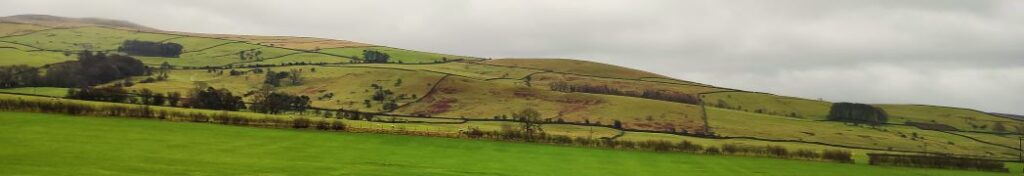
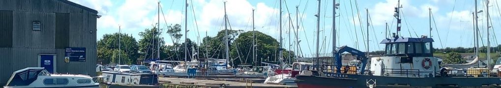
From convenient parking at Conder Green, we first head inland first through farms and up to the Lancaster Canal at Galgate. We then go south along the towpath until we get to the junction with the Glasson Arm, which we follow all the way down to Glasson Dock – one of the few places where our canal network connects to the sea.
The return from the Marina and Dock is via a disused railway line offering great views of the estuary, and there are several opportunities along the route to combine this easy and generally flat walk with pub lunches.

Glasson Dock and Lancaster Canal Spur Read More »

School Knott and Orrest Head

7.2 miles | 11.6 km | 368 m Ascent | 9.0 Naismith miles | Susan Badley
A quick glance at our website shows how much we like the fells to the East of Windermere – not only are they easy to get to from Bentham, but they are less crowded than some other Lake District destinations and offer some stunning views. This walk adds to our portfolio and starts from Ings where there is convenient parking.
We head toward Windermere via the viewpoint at School Knott, and then re-cross the railway and the A591 to find a route up Orrest Head via Common Wood.
We carry on heading north until we get to Far Orrest, then on to Town End via footbridges over Trout Beck. Finally, we return to the A591 near the Brockhole visitor centre, where we catch a bus back to Ings.

School Knott and Orrest Head Read More »

Dentdale

5.6 miles | 9.1 km | 302 m Ascent | 7.1 Naismith miles | Rick Clapham
Dentdale is one of the more popular gems of the Yorkshire Dales, and so not surprisingly, Bentham Footpath Group visit regularly. Every time we come here there is something different to see, and this time we start from the Church Bridge and take a riverside path downstream for a short distance before coming back to the centre of the village via the picnic area. We then head up the enchanting Flintergill, visiting an open air museum and enjoying a viewpoint, before climbing to the Occupation Road overlooked by the Megger Stones.
After following the Occupation Road for about a mile we head back downhill along a green lane to High Nun House, then cross the minor road and head down to Deepdale Beck which we follow downstream back to the Dee, which we then follow back to our starting point.

Dentdale Read More »

Bardsea and Urswick

7.4 miles | 11.8 km | 250 m Ascent | 8.6 Naismith miles | Terri Kwiecinska
In March 2024, Bentham Footpath Group walked at Flookburgh, and enjoyed views over the Cartmel sands to Bardsea. This time we are on the other side of the estuary for a great walk starting from Bardsea then heading inland to visit Urswick and its tranquil tarn. On the way we have the corresponding views back toward Flookburgh and the whole of Morecambe Bay. We also see a beautiful church, a curious three sided folly, get more than one ice cream opportunity, and pass the site of an ancient hill fort, before noting alpacas, highland cattle and a stone circle. We end by walking on the beach with opportunities to see and hear all the birdlife teeming at the margins. All this with free parking and public toilets.

Bardsea and Urswick Read More »

Wyresdale, Scorton

6.2miles | 10.0 km | 100m Ascent | 6.7 Naismith miles | Mary & Kate Taylor
For this walk we head southwest into Lancashire and park at the convenient Scorton Picnic site adjacent to the river Wyre, before we explore the riverside, the adjacent lakes, and the farmland in the Wyre valley as they come back to life as spring takes hold.
This is a walk without a great deal of change in elevation, and is quite short, so we class it as easy. However, it may be worth considering that in common with most riverside and valley bottom walks, how easy it feels may well change with the weather – heavy rain makes the paths muddy and slippery so if you are picking this walk for ease of use, make sure you pick a suitable day.

Wyresdale, Scorton Read More »

Around Gilpin Beck

6.3 miles | 10.2 km | 393 m Ascent | 8.3 Naismith miles | Alison Kinder & Colin Stroud
Sometimes our program works out such that we are in the same area for two consecutive walks – and that’s the case this time. This walk is at times no more than 200m from our recent Winster Valley walk, and at first we though that must be why a couple of locations looked familiar – we later realised that it is becase our equally excellent route at Lord’s Lot used a short section of the same paths from Spigot House to Bow Mabble Breast.
What does separate this walk from the earlier Lords Lot walk is the weather – we were rather unlucky this time. Despite that, there is much to recommend this walk – easy parking, rivers and tarns, woodland, working farms and some great views. Even in the rain it’s well worth the effort.

Around Gilpin Beck Read More »

The High Way Upper Wensleydale

7.1 miles | 11.5 km | 371 m Ascent | 9.0 Naismith miles | George Sheridan
Walking is a somewhat weather-dependant hobby, and this route demonstrates that clearly: When we completed our Grisedale and Garsdale walk in this area in June 2022, we enjoyed bright sunshine, walked over dry fields, and asked ourselves why bridges had been provided to cross mere trickles of streams. Fast forward to the wettest start to year that anyone can remember, and we see why the bridges are there – those same streams are now small rivers in full flow.
So, does the rain spoil the experience? Not at all, it just gives us a different perspective: Wonderful waterfalls roar into life, mosses and lichens proliferate, and we get extra exercise jumping over streams and fighting to stay upright on muddy descents. Whatever the weather, this walk offers a great deal – we rate it as easy based on the distance and ascent but be aware that there are steep sections and in the event of poor conditions, extra care is needed.

The High Way Upper Wensleydale Read More »

Dentdale circular

5.7 miles | 9.2 km | 248 m Ascent | 6.9 Naismith miles | Peter Lennard
We start by Church Bridge, and then loop up onto the fell at South Lord’s Land before walking behind the village, with great views across the valley, and then over to Gawthrop, before crossing meadows to get to Barth Bridge. From there we pick up the Dales Highway long distance path and follow it up to Lunds where we walk on an ancient green lane for a while. We soon head right and onto North Lord’s Land looking across the valley with views of where we walked in the morning. Finally, we return to Barth Bridge via High Barth and then take a very quiet road walk on the North of the Dee before one more section through fields back to Church Bridge.

Dentdale circular Read More »

Kettlewell to Starbotton

6.4 miles | 10.3 km | 335 m Ascent | 8.1 Naismith miles | Sandra Craggs
Kettlewell is one of the “Honey pot” villages in the Yorkshire Dales, and so during the peak of the tourist season, it gets rather crowded – and justifiably so – it’s a lovely place.
However, if you pick a glowering day during February when the weather forecast is gloomy, not only will you have the pick of the parking places, but all the paths will be deserted and if the weather proves to be better than expected you will still get some great views.
This walk takes us from Kettlewell up the Top Mere Road to Cam Head and then down Starbotton Cam Road into Starbotton. We then return along a riverside path enjoying typical Upper Wharfedale views. Although we class this walk as easy, based on the distance and total ascent, be aware that the first section is steep, though there are a couple of benches to take a rest.

Kettlewell to Starbotton Read More »

Kirkby Lonsdale and Casterton circular

5.0 miles | 8.1km | 164 m Ascent | 5.9 Naismith miles | Don Cartledge
This is one of our shorter walks – partly because we revised part of the route on the day to avoid flooding, and partly because sometimes it’s just nice to offer an easier route that can be used to fill a Sunday afternoon or a spare couple of hours on a balmy summer evening.
Despite being quite compact, this walk packs a lot in – we get to see the dismantled railway line that once linked Ingleton and Sedbergh, via Barbon, we walk on a Roman road, pass a number of Andy Goldsworthy art installations, catch a distant glimpse of a stone circle, visit the beautiful Holy Trinity Church in Casterton, walk on the access road to coal mines that can be traced back to the reign of Charles I, and all still have time left to get some shopping in Kirkby.

Kirkby Lonsdale and Casterton circular Read More »