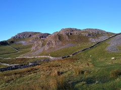
Dales Highway

Dentdale

5.6 miles | 9.1 km | 302 m Ascent | 7.1 Naismith miles | Rick Clapham
Dentdale is one of the more popular gems of the Yorkshire Dales, and so not surprisingly, Bentham Footpath Group visit regularly. Every time we come here there is something different to see, and this time we start from the Church Bridge and take a riverside path downstream for a short distance before coming back to the centre of the village via the picnic area. We then head up the enchanting Flintergill, visiting an open air museum and enjoying a viewpoint, before climbing to the Occupation Road overlooked by the Megger Stones.
After following the Occupation Road for about a mile we head back downhill along a green lane to High Nun House, then cross the minor road and head down to Deepdale Beck which we follow downstream back to the Dee, which we then follow back to our starting point.

Dentdale Read More »

Dentdale circular

5.7 miles | 9.2 km | 248 m Ascent | 6.9 Naismith miles | Peter Lennard
We start by Church Bridge, and then loop up onto the fell at South Lord’s Land before walking behind the village, with great views across the valley, and then over to Gawthrop, before crossing meadows to get to Barth Bridge. From there we pick up the Dales Highway long distance path and follow it up to Lunds where we walk on an ancient green lane for a while. We soon head right and onto North Lord’s Land looking across the valley with views of where we walked in the morning. Finally, we return to Barth Bridge via High Barth and then take a very quiet road walk on the North of the Dee before one more section through fields back to Church Bridge.

Dentdale circular Read More »

Sunbiggin Tarn and Great Asby Scar

7.9 miles | 12.7 km | 233 m Ascent | 9.0 Naismith miles | Valerie Eccles & Mary Pickstone
Limestone pavement is one of the defining features of the Yorkshire Dales, and when asked to think of an example, most people mention Malham: that pavement and the Cove are indeed spectacular, and Bentham Footpath Group have enjoyed a number of good walks there.
This walk however visits the much larger (15 square miles) and rather more secluded Great Asby Scar National Nature reserve. Malham famously has a tarn, so we throw one of those in and start at Sunbiggin tarn before taking a gentle climb to the scar using the Dales Highway path. We then head west along the top of the scar and visit Castle Folds, the remains of a Romano-British walled settlement. From there we pick up the path coming up from Asby Winderwath Common and circle round the scar to head down to the Gamelands stone circle, before taking the Coast to Coast path back to the tarn.

Sunbiggin Tarn and Great Asby Scar Read More »

Ribblehead & Chapel-le-Dale

7.8 miles | 12.5 km | 206 m Ascent | 8.8 Naismith miles | Valerie Eccles & Mary Pickstone
The Ribblehead Viaduct is probably the most photographed railway bridge in the UK, and an icon of the Yorkshire Dales. It’s more than just a bridge though; surrounded by stunning countryside, and with traces of industrial archaeology dating back to its construction, there’s lots to see. So where better to start a walk?
From Ribblehead, we head under the viaduct and over to Gunnerfleet before following Winterscales Beck down to the intriguing Haws Gill Wheel where the river disappears and then reappears. After a very short section of road walk, we pause at the lovely St Leonards Church, before heading up to Ellerbeck, passing a sculpture as we go, and from there take the Dales Highway back to the railway. After a brief look at the Signal Box at Blea Moor, we return via the Viaduct with views over to Ingleborough and Simon Fell.
The Dales’ favourite railway, that bridge, a disappearing river, a beautiful church, art, and great views.

Ribblehead & Chapel-le-Dale Read More »

Sharp Haw and Flasby Fell

7.1 miles | 11.5 km | 374 m Ascent | 9.0 Naismith miles | Sandra Craggs
Living in and around the Dales means that we often drive through Gargrave, and as we exit the town on the Skipton side, we see an attractive fell ahead of us with a wooded side and a ridge that looks inviting as a walking area.
That’s our destination for this walk: The woods are Crag Wood, and the peak behind them is Sharp Haw and Flasby Fell. Rather than approaching them from Gargrave though, we head over to the B6265 Grassington Road so that we approach Sharp Haw from the Southeast on the Dales High Way. This route keeps more of the spectacular view over the Ribble and Aire Valleys hidden until a big reveal at the peak of Sharp Haw. We then continue round Flasby Fell to Flasby Village and return via forestry tracks through High Wood and Crag Wood, enjoying excellent views over Gargrave toward Clitheroe.

Sharp Haw and Flasby Fell Read More »

Pikedaw Hill and Malham

7.8 miles | 12.6 km | 525 m Ascent | 10.5 Naismith miles | Sandra Craggs
Malham is one of the “honeypot” villages of the Yorkshire Dales – and the use of the Cove as a backdrop for filming “Harry Potter and the Deathly Hallows” has made it even more popular. There’s more to this area than the Cove though – stunning as it is – and if you pick a weekday out of season, you can still enjoy a quiet walk. This moderately challenging walk starts in Malham, with a steep climb up Pikedaw Hill, offering great views back to Malham and over toward Pendle.
We pass Nappa Cross, then head down the spectacular dry valley at Watlowes to the top of the Cove, where we take the Dales Highway path to Goredale Bridge and return to Malham village via the always delightful Janet’s Foss path. We grade the walk as moderate, but be aware that the first section is relentlessly steep, and potentially quite boggy – and that the dry valley requires particular care.

Pikedaw Hill and Malham Read More »

Austwick

6.4 miles | 10.3 km | 305 m Ascent | 7.9 Naismith miles | Bernie & Sheila Garrett
This circular walk starts from Austwick– where there is generally parking available free of charge on the roadside: For this walk we start by the Traddock Hotel.
We stroll through Austwick and out to the Horton Road where we pick up the footpath over Flascoe Bridge before taking the bridleway over to Feizor. The Dales Highway then takes us up toward Little Stainforth, but before we get that far we divert up to Smearsett Scar, before looping round to enter the top of Wharfe Wood.
We walk through Wharfe Woods, and then through parts of Oxenber wood before heading back downhill to Wood Lane which we follow as far as Austwick Bridge, and the Traddock.

Austwick Read More »