Kent Estuary

Ellerside from Cartmel

7.4 miles | 11.9 km | 203 m Ascent | 8.4 Naismith miles | Alison Kinder & Colin Stroud
Bentham Footpath Group has visited the Cartmel Peninsula a number of times: It’s a great place to start a walk and offers a good choice of routes. We could head east onto Hampsfell with cracking views over the Kent Estuary and into Morecambe Bay, or as we do on this walk, west onto the ridge at Ellerside with equally good views across the Levens Estuary and over to the Lakeland fells. Along the way we have the opportunity to explore Cartmel Village, potentially adding a visit to the Priory and Cartmel Park racecourse, before heading through Park Wood, and scaling Ellerside where from the top of a ridge running along the side of the estuary, we have great views over to Ulverston. Our return is south past How Barrow, then down to Low Bank Side where we pick up a lane back to the racecourse tracking the river Eea.

Ellerside from Cartmel Read More »

Levens and Heversham

6.0 miles | 9.6 km | 205 m Ascent | 7.0 Naismith miles | Don Cartledge
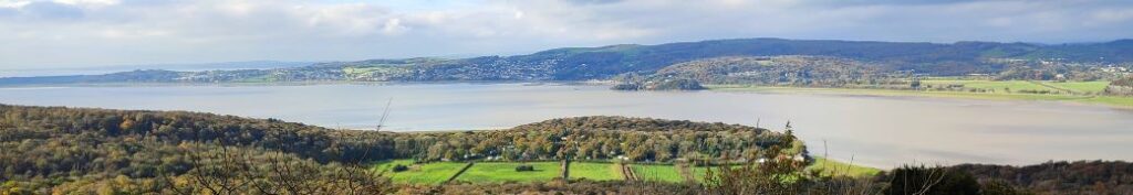
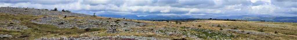
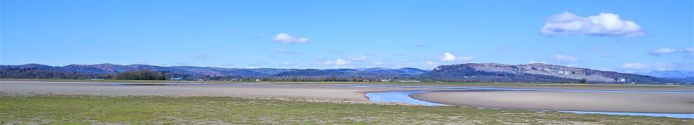
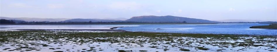
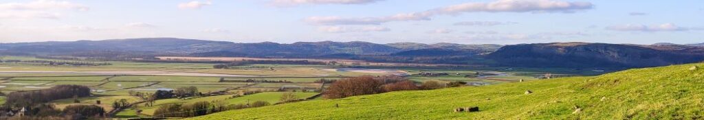
A quick glance at our website shows that Levens is a firm favourite of the Bentham Footpath Group, and this easy walk demonstrates exactly why – it’s convenient to get to, offers easy walking, is packed with interesting locations, landscaped parks and industrial heritage, as well as offering stunning views back to the Yorkshire Dales, of the Kent estuary, and over to the Lake District fells.
The route we present here overlaps in places with a number of our other walks – the great advantage of this is that you can use this as the basis for longer or more challenging days out by adding sections from the connecting routes.

Levens and Heversham Read More »

Heathwaite Coastal

5.3 miles | 8.5 km | 243 m Ascent | 6.5 Naismith miles | Alison Kinder & Colin Stroud
We are lucky enough to live in a location that gives us easy access to some of the most beautiful countryside in the UK, and we immediately think of the Lake District, the Yorkshire Dales, and the Forest of Bowland in this context. To that list we must surely add the Arnside and Silverdale Area of Outstanding Natural Beauty (AONB) – a compact but varied area that offers a wide variety of scenery, flora and fauna: One of the smallest AONBs, it covers just 75 km2 between the Kent Estuary, the River Keer and the A6.
This easy walk starts from the ever popular seaside village of Arnside, then takes a route along the coastal fringe of the Kent Estuary, looping round to Morecambe Bay at Far Arnside before returning via Heathwaite and onto Arnside Knott with its fantastic viewpoint. We end with a view of the fabulous gnarled trees on the Knott – complete with artworks – before taking a woodland route back to Arnside.

Heathwaite Coastal Read More »

Whitbarrow

6.7 miles | 10.8 km | 346 m Ascent | 8.5 Naismith miles | Terri Kwiecinska
In April this year, Bentham Footpath Group enjoyed a great walk at Storth and Arnside – that walk starts with a great view over the Kent estuary toward Whitbarrow Scar. This time we are on the other side of the estuary climbing Whitbarrow Scar and exploring the interesting geology of the area.
Whitbarrow Scar is designated as a Site of Special Scientific Interest, a National Nature Reserve, and a Special Area of Conservation, but still manages to offer easily accessible walks without being too crowded.
The route we take is loosely based on the Whitbarrow Geotrail – you can purchase a booklet describing that at the starting point. If geology is not your thing don’t worry – there are great views, fossils, birds of prey, abundant wildflowers, monuments, abandoned mines, forest trails, and newts to be seen too.

Whitbarrow Read More »

Storth and Arnside

7.4 miles | 12.0 km | 183 m Ascent | 8.3 Naismith miles |Sue King
Arnside is a firm favourite of the Bentham Footpath Group, and this is the second walk in this area in the 2023 spring program. So why do we like Arnside so much?
Well, where else can you find an easy walk that combines a sandy estuary with a backdrop of the Lakeland fells, a disused railway track bed converted into a safe and accessible path, industrial archaeology, beautiful riverside meadows, a country house and deer park, an ancient corpse road, atmospheric paths through rock fissures, a pele tower, and a seaside town with a unique railway viaduct.
The entire area is designated as an Area of Outstanding Natural Beauty (AONB) so expect to see interesting flora and fauna too.

Storth and Arnside Read More »

Fairy steps from Beetham

5.7 miles | 9.2 km | 309 m Ascent | 7.2 Naismith miles | Don Cartledge
December 2022 saw The Bentham Footpath Group walking from Heversham with views South toward Beetham and the Arnside and Silverdale Area of Outstanding Natural Beauty (AONB).
Just one month later, we start at the Heron Corn Mill in Beetham and then head through woodland and the famous “Fairy steps” to gain the complementary view – West across the estuary toward the Lakeland fells, and North toward Heversham and St. Anthony’s Tower.
We then skirt the estuary via the old railway track bed that we met on the Heversham walk, and then head up the river Bela, past Dallam Tower, and then though the deer park back to Beetham.
This walk is ideal for the shorter winter days – it’s relatively easy and offers a variety of landscapes as well as breath-taking views.

Fairy steps from Beetham Read More »

Heversham

6.5 miles | 10.5 km | 312m Ascent | 8.1 Naismith miles | Sandra Craggs
This short and relatively easy walk brings Bentham footpath Group back to the Kent estuary again – and on a good clear day (not the case on the day of the group walk unfortunately) – great views of Farleton Knott, then the Howgills, the Lakeland fells and finally the Kent estuary and the viaduct at Arnside are revealed.
Add a curious folly tower, an old railway line that is slated to be converted to a pathway, a toposcope, and a 12th century church with beautiful grounds, to make this a walk well worth the effort.
The route is essentially a figure of eight, so there is the opportunity to make it two shorter walks, and as part of this route intersects with other BFG walks, there is scope to use it as a basis for longer combined routes.

Heversham Read More »