2025

Pen-y-Ghent from Horton in Ribblesdale

6.2 miles | 10.0 km | 500 m Ascent | 8.7 Naismith miles | Valerie Eccles
When we live in and around the Yorkshire Dales, it’s easy to be blasé about the Yorkshire three peaks, or even to dismiss them as mere tourist attractions. That would be a mistake; all three offer a choice of great walks, and a series of views that changes with the season. On this occasion we tackle Pen-y-Ghent starting near St Oswald’s church, then going via Brackenbottom, to approach the peak from the southern side using the Pennine Way path. That gets the steep climb (and it is somewhat brutal) out of the way early. There is then ample opportunity to recover in the shelters at the peak before we embark on a gentler return to the north – still on the Pennine Way, before diverting to see the spectacular Hull Pot. Finally, we return to Horton by the Pennine Journey path.

Pen-y-Ghent from Horton in Ribblesdale Read More »

Aughton and the River Lune

7.1 miles | 11.4 km | 288 m Ascent | 8.5 Naismith miles | Mary Pickstone & Valerie Eccles
Our last three walks have been further afield – great for exploring areas we might be less familiar with, but not so convenient when we need a walk on the spur of the moment. This week’s route is much closer to home and is in an area that we are all very familiar with – the Lune Valley.
As well as being convenient, this walk has much to offer: We start at a wildflower meadow within the grounds of the Hermitage Estate, and head toward Halton Green before diverting through Higher Wood to get to Halton Park. A path through the edge of Wham Wood takes us to Hawkshead and a path along the top of the ridge to Aughton. This lovely village offers a good place to enjoy lunch, before we press on back down to the riverside at Aughton Barns. From there a riverside path takes us through Aughton Woods Nature Reserve before passing the spectacular waterworks bridge as we head back to our starting point.

Aughton and the River Lune Read More »

Horsehouse to Carlton in Coverdale

7.1 miles | 11.4 km | 232 m Ascent | 8.2 Naismith miles | Glyn Barnes
How many Dales are there in the Yorkshire Dales? It sounds like it ought to be an easy question, but it’s not. There is ambiguity about the area covered – is it just the National Park, or the wider area? There is also ambiguity about what a Dale is – is it anywhere where the name ends in Dale or is it a reference to the typical river valley geography? And what do we do where one valley has more than one name along its length – does that count twice?
When we start to list them, some are top of all our lists; Ribblesdale, Wensleydale, and Swaledale for example. Others are rarely mentioned, and Coverdale falls into that category.
In order to find out whether Coverdale’s lack of recognition is simply because it’s dull, we went for a walk from Horsehouse to Carlton and back exploring Swineside Moor and the meadows along the side of the River Cover. What we found was a lovely unspoiled area that is much quieter than the better known dales. So, let’s keep it that way – don’t tell anyone about this under-explored gem.

Horsehouse to Carlton in Coverdale Read More »

Train to Wennington – walk back to Bentham

5.4 miles | 8.8 km | 219 m Ascent | 6.5 Naismith miles | Kate Rowe / Kate Butcher
All of the towns and villages in our area are attractive places to live, and just about all of them make a good starting point for a walk. One of the ways in which Bentham stands head and shoulders above the others however is that it has a railway station, making walks based on a combination of rail travel and walking between stations particularly attractive.
This excellent walk draws on that strength: We take the train from Bentham just one stop to Wennington, then take a route back that gives us great views of Ingleborough and Tatham Fells along the way.
Being lucky with the weather always helps make a walk seem particularly attractive, and as the pictures show, we were indeed fortuitous this time, enjoying bright sunshine and early signs of spring.

Train to Wennington – walk back to Bentham Read More »

Rathmell

5.3 miles | 8.5 km | 147 m Ascent | 6.0 Naismith miles | Peter Lennard
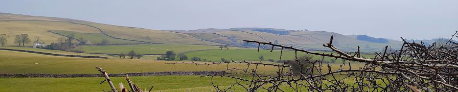
In July 2024, we enjoyed a great walk from Rathmell up to Whelp Stone Crag, and that walk impressed on us that walking in and around Rathmell had a number of attractions:
The area is much less busy than the “honeypot” villages within the national park, and there are great views across the Ribble Valley to Settle and Langcliffe with Pen-y-Ghent in the distance. Add to this convenient parking and a short travel distance from Bentham, and Rathmell clearly has much to offer.
It’s also an attractive village in its own right with some interesting history. The walk includes an ancient packhorse bridge that would not be out of place on any Yorkshire Dales calendar, and toward the end we get to see llamas and alpacas.

Rathmell Read More »

Melling circular via the rivers Lune and Greta, Wrayton and Wennington

5.9 miles | 9.5 km | 173 m Ascent | 6.8 Naismith miles | Mary Taylor
Over the last couple of walks, we have started to see the first signs of spring – with snowdrops, daffodils, and hazel catkins starting to emerge. The optimistic feeling that the winter might be releasing its grip was confirmed on this excellent local walk: We enjoyed brilliant sunshine as we walked from Melling over to Wrayton, and then on to the banks of the river Greta, following it down to its confluence with the Lune.
The original intention was to continue down the Lune and loop back to Melling via farm lanes. However, the recent rains made this route impassible, so our ever-resourceful leader provided an alternate route back: We returned to Wrayton as per the outbound walk, then took a path over the hill by Catgill Barn and down to the edge of Wennington Hall. A brief stretch on the road then took us to Lodge farm where we took a path that over the top of the Melling railway tunnel indulging in some industrial archaeology and then back into Melling.

Melling circular via the rivers Lune and Greta, Wrayton and Wennington Read More »

Ingleton to Cold Cotes circular

6.0 miles | 9.7 km | 164m Ascent | 6.8 Naismith miles | Don Cartledge
Picking a walking route during the winter presents challenges that don’t apply during the summer: Travelling time to the start of the walk eats into the available daylight, and so shorter more local routes are particularly attractive.
This week’s walk fits that description . . . but that sells it short: This compact route right on our doorstep offers great views, has a cafe on the route, visits a couple of idyllic dales villages, and has opportunities to either extend the route up onto the slopes of Ingleborough or onward into Ingleton. You could also shorten it in a couple of places if time is pressing.
The only downside is that you need to like stiles for this one – there are plenty of them.

Ingleton to Cold Cotes circular Read More »

Ellerside from Cartmel

7.4 miles | 11.9 km | 203 m Ascent | 8.4 Naismith miles | Alison Kinder & Colin Stroud
Bentham Footpath Group has visited the Cartmel Peninsula a number of times: It’s a great place to start a walk and offers a good choice of routes. We could head east onto Hampsfell with cracking views over the Kent Estuary and into Morecambe Bay, or as we do on this walk, west onto the ridge at Ellerside with equally good views across the Levens Estuary and over to the Lakeland fells. Along the way we have the opportunity to explore Cartmel Village, potentially adding a visit to the Priory and Cartmel Park racecourse, before heading through Park Wood, and scaling Ellerside where from the top of a ridge running along the side of the estuary, we have great views over to Ulverston. Our return is south past How Barrow, then down to Low Bank Side where we pick up a lane back to the racecourse tracking the river Eea.

Ellerside from Cartmel Read More »

Longridge Fell from Hurst Green

7.4 miles | 11.9 km | 267 m Ascent | 8.7 Naismith miles | Kate Rowe / Kate Butcher
Just one week on from a walk where the weather worked against us, we have a little more luck: This walk, like last week’s offers great views, but this time we got to enjoy them, along with interesting diversions on the way round. These include Cromwell’s bridge (which we drive past just before the start of the walk), the Shireburn alms-houses, The Ribble Jubilee Trail, Greengore – a buttressed hunting lodge once used by Henry VII, the fell top forestry path at Longridge Fell, a lunch break with jaw dropping views over to Parlick and Fair Snape Fell, Bleak House, sculptures of horses, the original site of the alms-houses – yes they were moved, and the manicured grounds of the famous Stonyhurst College. And as a bonus we got a free organ recital hearing the majesty of Widor’s Toccata. It’s only January, but this must be a candidate for best walk of the year.

Longridge Fell from Hurst Green Read More »

Bordley

7.2 miles | 11.7 km | 296 m Ascent | 8.7 Naismith miles | Sandra Craggs
We try very hard when we design our walks: We need to find starting points with suitable parking, and we need to find walks that offer a wide variety of interests on the way round. We need to think about where we can stop for breaks, and we need to think about whether changing conditions might make the route impassible – ideally, with an alternative if that’s the case. Finally, we like to offer great views – because that after all is such a big part of why we go walking in this wonderful landscape.
What we can’t do unfortunately is turn off the fog. So, today’s walk does have brilliant views . . . it’s just that they were hidden by mist and so don’t show on the pictures. Follow the route on a better day and we promise you there’s a lot to see.

Bordley Read More »