Jump to . . .Step by Step | OS Map | Downloads | Gallery | Fly through
Living in Bentham gives us easy access to the Yorkshire Three Peaks, and many BFG walks have featured them as their main attraction. This walk however takes a route between two of them without climbing either. Does that mean we miss out on points of interest? Not at all – the best views of the peaks are often not from the top.
We start at Chapel-le-Dale, using the car park for the lovely St Leonard’s Church, and then head up toward Ellerbeck, passing the interesting Statue of a Warrior by Charles I’Anson. From there we head left onto Scales Moor – in effect the southern slopes of Whernside, seeing some of the best limestone pavement anywhere. Once at Twisleton Scar End, we take a path down to Twisleton Hall, and then on to Oddies Lane – a metalled road, built over the route of a Roman Road, which sees very little traffic. This takes us back to Chapel-le-Dale, with great views of Ingleborough along the way.
- Total distance 11.9 km (7.4 miles)
- Total Ascent 206 m
- Easy walk
Step-by-Step
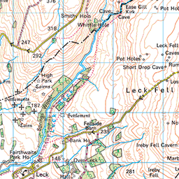
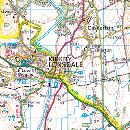
We start at the car park for St Leonard’s church in Chapel-le-Dale. The is easily found – take the B6255 from Ingleton toward Hawes. Pass the White Scar Caves, then 1500m (1 mile) later, look for signs to Chapel le Dale at a minor road on the left. Head down there, then just 100m after leaving the B6255 go left again into the carpark. The gate to the carpark may well be closed, but it is not usually locked, and this convenient site may be used in exchange for a donation which may be left at the honesty box at the church. Please give generously and respect the fact that the carpark is primarily for the church and worshipers – taking parking spaces when they are needed by the congregation would be inconsiderate.
For those using Satnav to get to the start, try the address for St Leonards – Roman Road, Chapel-le-Dale, LA6 3AR, or if your device uses what-3-words, the tag is obeyed.aunts.fruits whilst the OS grid reference is SD73837715.

From the car park head back to the minor road and turn left toward St Leonards. The postal address for the church identifies the minor road as Roman Road, with the modern name reflecting the fact that it is built over the route of a Roman road that we have encountered on other Bentham Footpath Group walks. It is usually referred to as the Cam High Road and fits into a numbering system for all known Roman Roads in the UK via its “Margery number” of RR73. Click here for more detail of RR73, and here to learn more about Margery numbers. If you wanted to walk more of the RR73, try these other Bentham Footpath Group walks:

After no more than 100m on the Roman Road, we arrive at the Lychgate of St Leonard’s Church. Regular walkers with the group will remember this from our Ribblehead and Chapel-le-Dale Walk.
St Leonards was built in the 16th century as a chapel of ease – a church building subsidiary to the parish church, built for the attendance of those who cannot reach the parish church conveniently, generally due to geographical constrains. In this case the main parish was St John the Baptist in Low Bentham, about 8 miles away.
Like many of the small Yorkshire Dales Churches, St Leonard’s is worth visiting simply to enjoy the beautiful setting, but in this case, there are a number of additional features which make this a particularly noteworthy site:
It is the burial site for the many men who lost their lives in the construction of the Ribblehead Viaduct. This is marked on a white marble memorial which reads: “To the memory of those who through accidents lost their lives, in constructing the railway works, between Settle, and Dent head. This tablet was erected at the joint expense, of their fellow workmen and the Midland Railway Company 1869 to 1876”.


More than 200 Ribblehead labourers, their wives, and children are buried at Chapel-le-Dale. Funerals were so numerous during construction that the churchyard had to be extended to contain their poor, unmarked, and often unremembered, graves. As well as falling victim to what we would now call industrial accidents, many died of smallpox during an epidemic that swept through the timber huts in 1870.
We all refer to this church as St Leonard’s (the patron saint of prisoners, women in labour and horses), as indeed does its own signage, but curiously it has never been formally named as such. The first written reference to the chapel dates to 1595 and refers to the Chapel of Wyersdaile. It was called the Chapel of Witfalls in later documents, and by the 18th century was generally known as the Ingleton Fells Chapel.
It has only been known as St Leonard’s since the 1940s, when a reference to St Leonard’s in Ingleton (now dedicated to St Mary) in an old will was mistaken for a reference to the chapel. In fact, the chapel has never been officially dedicated to St Leonard. For more on St Leonards, click here
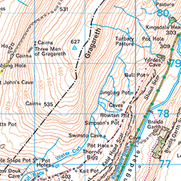
Just beyond St Leonards there is a lane on the right – we take this and head up toward Ellerbeck. We pass signs for a number of properties on the way up but ignore all of them and stay on the road, which soon degrades into a rough track as it heads uphill. We pass a pothole, on the right, behind St Leonards – this is known as Hurtle Pot. Don’t be surprised if you miss it, it’s not particularly visible from the track, but it is clearly well-known to local miscreants, as they relocated a statue from a site next to the lane to the bottom of the pot in 1983.
The artwork was created by Charles I’Anson and is known as the Statue of a Warrior. It has stood at this location since the 1960s but was vandalised on Saturday August 27th, 1983, and subsequently found in 30 feet of water at the bottom of Hurtle Pot. An enthusiastic team of divers managed a retrieval, and it has been re-erected, this time in a deeper foundation.


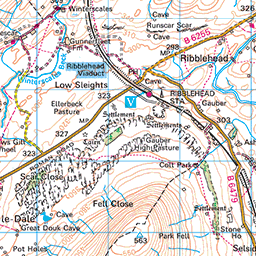
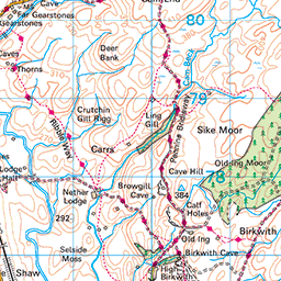
We continue up the lane through an atmospheric mossy woodland, and then exit the trees to walk along a flatter track toward the flank of Whernside – with views of the Ribblehead Viaduct over to our right as well as of Whernside itself.
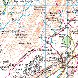
We are heading northwest now, and as we progress further, we catch sight of, and then approach, Ellerbeck Gill. During dry weather (which according to myth can happen here) this is a small stream, but it swells to a fast flowing torrent during wetter periods. We soon reach a point where we find a fingerpost offering us a choice of routes – to the right we could cross the gill, then head over to Deepdale, Whernside and Ribblehead, or as we do today, we can go left and across Scales Moor toward Twisleton Scar End and Ingleton. Before we head left though it’s worth looking further up the Gill – there is a waterfall that is well worth seeing – particularly when the flow is strong.
We are now walking on the Pennine Journey path, heading southwest, and continuing to climb gently. The route should be clearly visible – it’s a popular path, but if in doubt stay below the steep flank of the hill, but above the limestone pavement, until the path takes a dogleg through the exposed limestone at Rantree Moss. We then continue southwest, and once at the highpoint, pass a curious and rather intriguing jaw like hole where water has eroded a route though the limestone pavement and through into caverns below

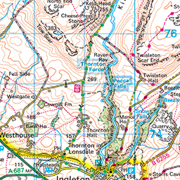
Our path soon reaches the end of the flat(ish) plateau, and we start our descent toward Twisleton Hall. Don’t be concerned if you can see the hall over to the left whilst the path initially heads right – it soon changes direction as we head downhill.

We continue down and soon arrive at a track that is part of the Ingleton Waterfalls walk, although this section is a public right of way. We go left, through a wooden gate and down the lane toward the hall. As we arrive at the buildings there is a track on the right – this heads down into Ingleton, and is worth exploring another time, but for now we carry straight on following the Waterfall Walk signage over a stile and down to the minor road – we are now at Oddies Lane.
Once we arrive at Oddies Lane, we turn left and follow the Roman road for a while, though you will notice from the GPS on the website that we took the opportunity to go to the café just beyond Oddies Lane before continuing.
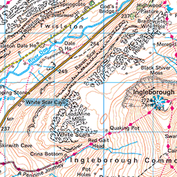
The route back to our start is now very simple – we just stay on the Roman road for about 2 miles until we get back to St Leonards. As we make our way northeast, on the long side of what surely must be the most rectangular route we have ever devised, we have good views of Ingleborough with the River Doe in the valley bottom to our right. If you wanted to add a riverside picnic to this walk, there are four paths which head down from the Roman road to the river. Three of them promise stepping stones where the river might be crossed, although on the day of our walk, as you can see from the gallery, this is not always a good idea.


If you do head down to the river, please keep to the permitted paths – the flower meadows here are particularly impressive and deserve protection.
Over to our left, we have the impressive Twisleton Scars, and along the base of them a number of springs where some of the rainwater falling on Scales Moor emerges having percolated through the limestone. These springs feed small streams, which head down to the Doe. Many of them completely disappear under dry conditions – although there are some which remain as reliable water sources all year and which are still used for drinking water supplies to the isolated farmsteads.
The valley here has a long history of habitation, although as we stroll through it, little is visible to the untutored eye. Documents from as far back as 1506 show that the Dale was once called Weysdale, whilst maps from 1755 show the river as the Wees. Aerial photography and old maps of the field boundaries show limestone terraces, and fields in the valley show signs of ancient parallel banks and a wood field – an agricultural practice in which trees were used to shade and shelter the animals. Primrose growth in striking abundance in an otherwise unremarkable area is often a good indicator of the site of this old practice – even when the trees have since been lost.
For more on the history of this area, we recommend the website of the Ewecross Historical Society. Click here to visit


We press on northwest, and soon arrive back at Chapel-le-Dale – there are just a few houses in the hamlet, all of them attractive. Worth noting on the way through the village is the old well – no longer used but once the source of drinking water for the residents.
We arrive back at St Leonards – and in our case took the opportunity to look inside at the rather beautiful stained glass, before walking back down to the cars where the walk ends.
At just under 12 km, this route just about stays within our “easy” category but be aware that it requires care in wet conditions.